
Friday, July 24: Got up pretty early, as I’d done in the past to try to get a jump on the heat. I just have a terrible time once that temp gets up in the 90-degree range, and today was forecast at 95 or more. So I was up and working at 5:20 AM, then we got everything transfrered to the van, we ate, and were on the road for the 35 mile ride to where I left off yesterday, when I made that nice little gaff of leaving the bike behind.
This first section, Black Dragon Canyon, was going to be a real tough go, so as I’d decided yesterday, I was going to ride it in reverse direction, starting up at the top, about 1K feet high, and then descending the canyon down to where I left off yesterday afternoon at the little BLM gate. From what I’d read and ascertained on the maps, this pup is just some real serious track, with sand washouts sections, tons of loose rock and boulders, and you name it. Basically it’s more motocross and ATC track. I didn’t see anything about actually being able to take a vehicle on this thing. So doing it as a climb, that would likely be a 4 hr trek with lots of bike hiking, as opposed to 2 or less if done as a descent where you’re on the bike a WHOLE lot more.
So we proceeded up the long climb on I-70, through the San Rafael Swell, and then just continued to do this long false flat climb to exit 131, where the route comes out onto Frontage Rd, my day’s start point. Got on the bike at about 7:40 AM, in pretty good temps and a nice bright blue sky. Got going on Frontage riding east, which paralleled the interstate for a mile or so, then it turned north. Rode another mile or two to the junction with Sinkhole Flat Rd. This was kind of a nice little descent down some dbl track for a couple miles out in the high plateau area. Then the next turn was a L, east on an unmarked dbl track. At this point my gps just says I’m riding on a road. There’s no mention of the name or anything. But I’d memorized all the turns because this place is just a maze of small BLM roads, many of which just don’t have any marking whatsoever.
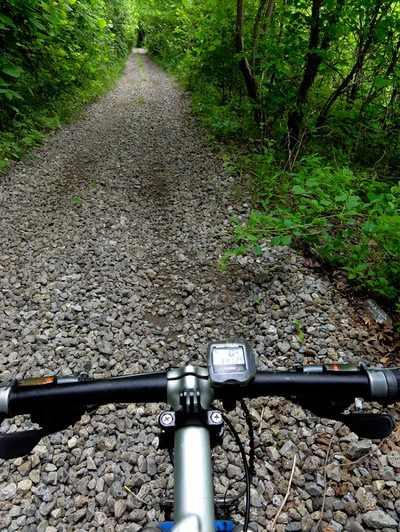
Rode this for another mile or so to the next turn, a R, east into the Black Dragon Canyon. Now this guy was marked, so I knew I was on the right track, despite a number of R hand turns along the way. Man, I would have had to get the exact latitude and longitude coordinates if that weren’t the case. So I took this thing and that’s when the fun began. And when I say fun, I say this kind of jokingly, because this thing is some pretty serious riding. There’s slick rock sections, drop-offs, sand and boulder washes, I mean you just had to keep your eyes on the trail ahead of you rather than gaze out at all the eye candy scenery in front and at your side. There were a few sections where I had to dismount and walk the bike down due to the really hairy nature of the drop-offs with loose boulders and rocks. I’m ok with the 2-3 foot drop-offs, but when there’s just a big pile of basketball sized rocks at the bottom for 10 feet or so, that’s where I draw the line. But by and large most of this I was able to ride without being too wigged out. Now mind you, these 4-5 miles weren’t even the canyon, it was more like this series of benches that continued to go down towards the actual canyon. Off to my right I could see the view area just off of I-70.
We’d stopped there yesterday to look at the trail way off to the north, and you could actually see it from up there, and it looked pretty good….from like two miles away. Being right there on it and it was this wicked motocross track that snakes it’s way along this big bench. And you can just see those massive 500-800 foot walls looming in the east as you’re riding down dip towards the canyon. Once I began to see these little slot canyons on my right, with like a hundred or so foot drop offs, I knew I was entering the guts of the canyon. This is where the real riding began, and I was thinking to myself the whole time, “I am SO glad I’m riding this thing as a descent, because it was equally as brutal as the Hermit Pass climb - which I hike-a-biked for God knows how long.
I’d get occasional give-me’s where I could let the bike run for several hundred yards, but then I’d hit a wash for a half mile where I was fighting the sand and gravel just to keep the bike upright. There were a pair of motocross tracks in there so I figured that I’d use those as my lines of choice. Otherwise, you have kind of a myriad of ways to track through the washes. Once you get out of a wash, you’re right back up on this really thin dbl track, so thin that only an ATC could make it. This is not a place for 4WD trucks, just too narrow. Once I made it deep into the canyon, the walls were towering over me for hundreds and hundreds of feet. Riding this thing really gives you a perspective as to how wide this San Rafael Swell really is. I mean this thing is massive, and I’d see sunlight around the bend, thinking that I was nearing the end of the canyon, but then I would just snake and descend for another mile. I went through this numerous times, to the point to where I just accepted the fact that I had a LONG ride ahead of me.
Towards the end the wash actually had some water, where I’d hit this wet sand and silt, but it was really nothing to worry about from a getting soaked perspective. The walls at the end really get confining, kind of like you’re riding in this slot canyon, and most of this is just riding down the middle of a wash. By the time I actually rode out of the canyon, my hands and shoulders were just smoked. There was just very little chance to loosen up on the descent. Heck, I had a fly biting my arm and I just couldn’t take the other hand off the bar to swat the bastard. Had to wait about a minute, when I was down in this wash to go one-handed to smack the thing. Made it out and the track opened up to about a lane wide, and it undulated up and down for a bit before finally descending all the way back down to I-70. I was very happy to see that van down there.
Got back to the van in 1:50 hrs to descend 21 miles. I think my total gain in elevation for that segment was about 100 ft, so you know that you’re doing nothing but going down, down, down. Must have dropped about 2500 feet in that 21 miles or riding - nothing as sustained as Hermit Pass, but serious nonetheless. Judy had some food ready for me and we got going west on I-70 to the next segment, and I was riding this one in the same manor - west to east so as to take advantage of the larger net descent. We drove back past exit 131, where I started the Black Dragon Canyon ride, to exit 116, where I’d start near Eagle Canyon, and finish back at exit 131.
Again, I knew this pup was going to be another serious ride, at least for 8-10 miles of the lead in to Eagle Canyon, and then Eagle Canyon itself. Got to exit 116, and did a final map and directional check before I headed out. I had Judy drive back to exit 131, and park on the eastbound side of the road where I’d come out. I told her again that this could be anywhere from 2-3 hrs, and to just relax and stay put. Off she went and off I went, on Copper Globe Mine Rd. It went to the east for a short stint, and descended sharply, then did this dogleg to the north and went under the interstate. This was wide enough for a really small vehicle, but not full blow 4WD machines.
There was some good signage on this track, which was just after I went under the interstate, and pointing me in the right direction to the beginning of the Eagle Canyon track. This, just like the Black Dragon Canyon descent, was just a motocross track, and a steep one at that. I thought my sphincter was tight on the BDC descent, man the beginning of this little track was just treacherous, and I had to walk the bike on several occasions because the drops were so big and the boulders were so menacing looking at the bottom. Got to the bottom of this track and a sign pointed to Eagle Canyon, which I thought would be more of a jeep track….WRONG! More of the adrenaline pumping descending I’d just done.
And the washes, damn, these sand washes were like quicksand, and I washed out the tires several times. I did a ton of shifting on this thing, going middle ring on the slick rock and ledges and rocks, and then little ring in the sand. And you had to be careful though when coming off a steep rocky descent and going right into a sandy wash, because the tires can just go anywhere in the sand once you hit the wash. It’s a double edged sword because you need speed to get through the sand, but that speed can cause you to crash if you just hit the sand and the bike slips out from under you. It’s a delicate balance.
Now I was working my ass off on this track because it wasn't all descent. There were a ton of these punchy little climbs where you had to shift fast into the little ring, with the easiest rear cog and then just try to pedal like hell to get up this rock and boulder strewn climb without biffing. I was Z5 numerous times as I crested these things. So Eagle Canyon is called BLM 820, and all around are these other tracks coming and going off of 820. I just made sure to really watch for these small plastic BLM trail markers as I continued through the canyon, because I needed to veer to the L and go up past Swasey Cabin and stay on 820, or else I’d be riding south to Taylor Flat and into a massive maze of trails.
On the bright side I have to say that this canyon really reminded me of Zion Canyon, but on a much smaller scale. The rock walls, the orange and yellow colors, and the brilliance of the walls lit up in the sun made for a spectacular sight. I stopped several times when my heart rate was going through the roof to take some still pictures of the canyon. But as I said about Black Dragon Canyon, you’re just so focused on the track, and not screwing it up that it’s hard to appreciate the scenery. Hopefully my GoPro video with do it justice.
Made the turn and began climbing out of the canyon on a series of those punchy little cookie climbs for 2 miles. There was a point where I got over the 4th or 5th of these and I just had to get off and bike hike for 5 minutes to catch my breath. I mean I was tasting lung tissue! And nothing was sustained for climbing. It was just all these steep little things that just sucked the life of me. Finally got to the cabin and then the track changed from motocross track to single lane gravel road. God, I was so happy to be able to relax my hands, arms and shoulders. This took me to the junction with BLM 6852, where I went L, north towards this rock mesa called Head of Sinbad. From here I was on a great dbl land gravel-dirt road that took me back up towards I-70, and then bent back around to the south.
The rest of the ride was really super relaxed, where I could ride no handed, look around, enjoy the solitude, have fun. At the junction with BLM 7196, I went L and took that back to the main gravel road, Temple Mt Rd. Went L on Temple Mt and took that back towards the junction with exit 116. By this time Judy had started driving towards me on Temple Mt, worried that I was gone too long. I motioned her back to the BLM kiosk where I would end the ride. For the last mile we saw a herd of wild donkeys out grazing to the south.
Got done at about 1 PM, and THAT was a day, for the heat by then was in he 90’s, and for us to drive back to exit 116 and then for me to do another segment heading west, that would just be too long to do in the heat for the day. Ended up with 42 total miles for the day in about 5 hrs of riding. My total gain for the second segment was just over 1K in elevation, but all of that was a combination of those short, steep little climbs.
Right now my legs are still twitching from muscle spasms - likely due to those 10’s of anaerobic climbs power climbs. Have to say that this is just as difficult as doing the passes back in CO, it’s just a different kind of difficult. There’s weather concerns out here in UT, but it’s for the heat, not for rain and lightening storms we faced in CO. And of course there’s climbing, but it’s not the high altitude stuff that went on for mile after mile, it’s these anaerobic lung twisters that come at you in 2’s, 3’s and 4’s. So I have two more of these kinds of segments to go before things settle down a bit. I’ll hopefully get both of them in tomorrow + some of the easier Frontage Rd stuff next to I-70, and then we’re off to Salina for 2 days as I work my way west.