
Blog
Blog
Sunday, May 31: Well, no thrashing sessions today, at least not on so-called “Railtrails”. And man, my upper body was just lit up this morning from all the bike portaging yesterday on that Moonville trail. Maybe it’s just that I’m getting old, or maybe it was a lot of bloody lifting. Whatever the case, my neck, traps & lats are feeling a bit sluggish right now.
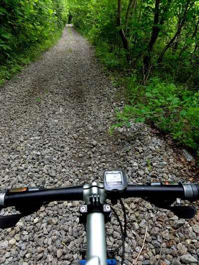
Got going at 8:30 AM right out of Lake Hope State Park. Now I could have done another 4 miles on the Moonville, but checking out my gazetteer last night I counted another three Xing’s of Hewett Creek. Honestly, just didn’t have it in me so I berminated my way down Rt 278 south to Zaleski- and man, THAT was a wise choice because I could motor along at like 10 mph on this beautiful sandy berm. And you’ve got to realize that 10mph to me is like the Autobahn after the last couple of days riding. Made Judy happy to because she could always keep me in sight. So made Zaleski in no time. Then did berm on Rt 677 south to Red Diamond. Now the old RR line actually starts back up outside of Zaleski and continues all the way to the southwest where it joins up with a CSX main line just south of Chillicothe. Problem is that from Zaleski to Red Dimond, the line is kind of off-limits due to this Powder Plant being smack dab right on top of the RR. So it’s fenced off for some 3-4 miles in each direction. Don’t know what they do there…but they’re pretty big on security, so I wasn’t about to even get myself inside of that mess. , and this thing is massive. No choice but to berm ride, and again, the riding was pretty smooth, so we made great time to the town of Dundas. From Dundas the - we’ll call it a feeder line - power plant rail parallels a collection for roads. So I had the choice riding Rt 93, or riding down the middle of that single old RR. And I bounced back and forth based on how the berm/rail riding difficulty level was.
Again, Judy was pretty happy to be able to kind of stay in close contact. She’d go 2-3 miles down the road and just wait, then we’d confer on whether I’d ride rail or berm, and then proceed down the line. At the town of Hamden we took a break with about 20 miles in the bag - a massive day for me at that point! From there we got on this little county road called Lesmil, and the berm was just total crap, which in berminator lingo means THERE WAS NONE! So I was on the RR riding down the middle with the road and the RR line almost touching one another in places so Judy and I could still keep an eye on one another - until the first wrench in the cog for the day - when all of a sudden there was a “Dead End” sign on Lesmil. Now I could keep rolling on RR, but Judy was in a quandary, and honestly…so was I. I’d used gazetteers and google Earth to do a lot of my mapping for this trip and both of these had Lesmil being a thru road all the way to Rt 327. BUT when I pulled out my gps it come up as a dead end. And on the other side, my gps says the same damned thing - dead end. Amazing!
So I had to add lib a bit to get this thing done to Rt 327. Now Judy wanted no part in my add libbing with her getting on roads I hadn’t previously researched. I mean hell, I’ve screwed up routes that I HAD researched so I totally got her uneasiness. Loaded my bike in the van, pulled out my gps again and began zooming in on a van route to get us past the dead end thing and get us to Rt 327. Wasn’t too hard with Judy driving and me navigating with a gps. Made it to the other side with no problem. So I decided to berm ride from that end point back to our start point so that Judy would be ok. And actually it was much better than what I’d just ridden on the RR so it worked out ok. Minor problem, major fix. And we were back in business in the town of Byer.
From Byer west Rt 327 goes dead parallel with this same old feeder line, so again I had a choice of two evils - berm or RR. Berm won out with some great sections where I could bump up the mph to 10 and 11 on occasion. Took this to the little hamlet of Ray. From Ray, again, the RR paralleled another west trending road - West Junction Rd. BUT, big issue here was that once you pick your poison, you’re committed, because the parallel really isn’t that close, and there are no roads to connect the two. I chose the berm of West Jnc Rd just to kind of keep Judy and I together, because she wouldn’t be able to see me at all once I’m on the RR line.
Bad choice…VERY bad choice. The berm on West Jcn was just abysmal. Some of it was a fine, loose gravel that sloped down at 45-50 degrees, which just made both my wheels wash to the right down into deep ditches. Couple of time I just had to ride a section of asphalt just so I wouldn’t plant my ass face down in a five foot deep ditch. I’m all about the ethics of this trip, but I’m not going to get stupid about it. So I had several of these episodes. The good sections of berm on this tiny county road were about 6-8 inches wide where you’re teetering on this thin little line. Go right just a smidgen and you’re ass over tea kettle in the ditch. By now I’ve become very proficient at holding a good line and looking down the road. Those big fat 2.4 tires also help out.
By the time I made the town of West Junction to meet Judy I was pretty flamed from the berm ride over the prior 5 miles. Now to get to our next meeting point, I had to go full RR line and Judy had to go full little 1.5 lane backroads, and she wasn’t too keen on doing these on her own, so what I did was another reverse segment where I co-piloted her to what was to be my end point, and then got out and rode the RR line back to where I ended up in West Junction. Worked perfectly as Jude could get back to West Junction having already driven from there. And I could ride RR because there was on other option. Only down point is that we’re using double the amount of gas and it’s taking more time…BUT if she’s happy I’m happy. So we’re good.
By the end of this section my ass was feeling like I had a bad case of diaper rash, what with all the jarring from riding down the middle of RR half the day. I mean I even told Judy that I was going to have to get some baby powder for my sore red ass! So again, we drove back to where I started that RR segment for the final segment of the day, from Richmond Dale to just across the Scioto River, some 11 miles south of Chillicothe. Did that all on berm and we were done.
Feel like I at least got in some distance today, I’m guessing like 40-43 miles - huge day since we got going again last Thursday. Tomorrow is kind of technical in that I need to get past Chillicothe via no asphalt if at all possible. Got two choices here: First is to just paddle down the Scioto River to where I ended up today; OR to do 6-7 miles on a “somewhat active RR line” that has this bomber dbl track on the left side - very alluring! Bad part about option two is that I just have not been able to find a put-out point if I ride the RR and paddle half. All the put-outs are on private property. So I’m going to do a bit more research tonight and make a decision then. Until tomorrow….Late
Blog
Saturday, May 30: I left off yesterday about picking my poison for today. I chose Hemlock! Because it damn near wrecked me.
So I’d decided last evening to try to continue on the abandoned RR line that leads from Athens to Lake Hope SP and eventually Zaleski. The first half, from Athens to New Mansfield, is not designated as anything in the form of an official trail, and in some areas it’s reverted back to the owners since there’s a law of some sort that gives the right of way back to the land owners if the rails are pulled out and the right of way lays vacant for X amount of time. This I schooled myself on as I researched these old rail lines. Now sometimes the right of way really isn’t acted upon, and in other cased people either put up “No Trespassing” signs to keep the ATCers out, build on the strip of old line, use the old line as a driveway or personal ATC track, or the line is obliterated by businesses, roads or houses. It really varies.
The second half of the trail, from about Mineral, a 2 trailer town just west of New Mansfield, is designated as the start of the Moonville Railtrail, and it goes all the way to Zalerski. It has no designated trailheads and is mainly undeveloped… and you know what that means! So I decided to do as much as the non-designated section from Athens to New Mansfield as I could without trespassing and then do berimator for the other sections, then I’d ride the infamous Moonville trail in it’s full length. Judy dropped me off at my finish point from yesterday and I began the day’s ride doing berm, which actually wasn’t too back. Took Luhrig Rd which parallels the old RR line. Now this is one of the sections where people have posted No Trespassing signs, used the old line as driveways, built houses on the old line, etc. So it was pretty much a done deal not to go meddling on someone else’s property. Good thing too cuz the sections of old line still intact were just bloody horrible looking. I was 3x faster just doing the berm on this 1.5 lane country road instead of thrashing along the old line.
So we did this for about 5 miles up to a point to where the old line do this straight line through a 3 mile stretch of woodlands into the town of New Mansfield. I was intent on doing this section since it was totally away from roads and houses. Had Judy just go straight to New Mansfield where I’d meet her at the end of this segment. So Judy drives off and I enter the old RR line on what looks like a driveway next to a trailer with all sorts of junk piled up all over the property. I didn’t get but 5 pedal strokes in and this lady comes out and asked me what I was doing. “I’m riding to New Mansfield,” I replied. “Not on there you’re not,” was her response. So I asked her if there as an access to the old line somewhere else closeby. She said, “yea, get yourself on that road there, this is private property”.
Now if you’d have seen this woman, and I use that term very politely, you’d have done just what I did - get the hell out of there. She looked frightening, and what I feared even more than her was the potential that she had a hubby who weighed three fitty, who was sporting a dbl barrel shotgun and spitting chewing tobacco. That thought turned my lycra clad ass right around to the road. Yup, that sealed the deal for sure, so I knew from routing Judy to New Mansfield that that’s the same route I’d have to take. Wasn’t even about to try to pull a fast one on these Southern Ohio folks! Did berm all the way down Salem Rd, then more berm as I rode west on Rt 56. Some sections were good, some downright sucked. But I got to New Mansfield in descent time. And as I was riding, I thought about not being able to ride that section. More than likely, since I’d seen where the old RR line comes out on the east side of New Mansfield, and it was NASTY looking, that it quite possibly have been a complete crapfest. Maybe Miss congeniality saved me a ton of trouble?
And that was pretty darned easy actually considering all the crap from yesterday. So next up was the section I’d seen yesterday with the well worn ATC track on it. I told Judy I just didn’t know what to expect on the next segment, could be golden all the way, or it could be a little section of ATC track leading me into a complete nightmare. Gave Judy directions to Lake Hope SP and asked her to meet me at the damn. For this section there is no chance of any other support - you go all in and hope you can do it cuz the phones don’t work and there are zero parallel roads along this thing for most of it’s length. It just goes through miles of wetlands, swamps, lakes, streams and woodland. It’s part of Zaleski State Forest and it’s pretty wild. It IS THE straightest line to the state park. If I would fail at staying with the Moonville railtrail, then I’d mega miles of road to get me into the park. But hey…this is a designated trail. Even has a website. Can’t be that bad!
So I’m thinking all this as Judy drives off and I head down this great dbl ATC track. “Looks damn good,” I was thinking. “Wouldn’t it be refreshing if this thing was like this the whole way to the park,” I even said out loud to myself with a giggle. I had this one coming to me. Within a mile the ATC track ended and the old RR line turned into nothing but jungle. So I got on this paralleling road and did berm riding trying to stay with the old line. But within a mile it disappeared. So I took a left on another tiny little county road and did berm on that looking and looking to me left and right for any sign of the old grade. Then about a mile down the road I see this collection of ATC track, and just above them is the old line. BUT there are these No Trespassing signs up on the tracks that are along the road. I wondered if they applied to the sides along the old line…or to everything? I mean from what I’d understood that section was designated as trail. So I went for it and accessed the RR line. Rode on some great dbl track ATC again and that lasted for about a mile.
But slowly, the ATC dbl track kind of petered out to just single track, and then foot trail and then it went by this dirt road…and dead ended at an old RR abutment, with a creek down about 50 feet. I mean there was zero access to get across. None of the ATC guys had blazed a trail through there. Went back out to the gravel road and saw that it went way the hell up into the hills, far from the RR line and the stream. As I said before, you get to a point of no return on this segment, and I was at the gates. I knew from the past with bushwhacking, if you open that door, you usually get far enough in so that there’s become no choice but to continue. So the road option was out, I mean going back to the start and trying to do berm on main routes, that was NOT an option. It would take the day to accomplish. What really made my decision was that this WAS a designated trail, the Moonville Railtrail. So I took to pushing my bike through a field about 300 yrds from the abutment so I wouldn’t have to descend down the steep slope to the stream, then waded across the stream with bike in tow, ascended up the steep embankment on the other side, and bike hiked the bike down the trail.
Was able to ride just a short stint, and then another abutment, another descent, another stream Xing, this one as I did a tightrope walk across a big deadfall carrying the bike, then another ascent up the steep embankment, and another shot stint of riding on this gametrail on ballast through saplings, thorns, briars, and vines. Now multiply this scenario 5 more times. NO kidding - 7 of these Xing’s. By number 5 I was saying to myself, “I physically don’t know how many more of these I can do.” and then another abutment, another creek, and more climbing and descending up steep slopes with a duel suspension 29er. Now as I went along single track actually started to appear, and I could ride these sections pretty well. They were still on golfball sized ballast and the width of the trail was super narrow - again, thank goodness for my narrowing the bars before the trip. But I would get slapped now and then by branches and raked by thorns. Thankfully I was wearing my bush pants and not even wearing cycling shoes, but my hiking shoes instead. This seems to be the theme right now for cycling: bush pants and hiking shoes - as I ride with eggbeater pedals!
So anyway, I did 7 of these things, and it was beginning to feel like Groundhog Day. Just kept going, thinking that THAT was the last one, and heck, the trail was getting more and more defined, so it was not digressing. Finally came to this section where I saw people. One guy at first, then a few more. Knew at this point I was very close to the state park, cuz all the people were there to walk through the Moonville tunnel, one of two tunnels I’d already ridden through. Felt pretty good at that point, so I continued on the railtrail, and be damned it not more than 200 yrds down the trail was this monster abutment, and a creek that had to be 5-6 feet deep and 2yrds wide. This was number 8…and I was DONE with abutments, creeks, steep slopes and dragging a bike.
Now I knew from recon work that this area was very close to the park, and come hook or crook, I was freaking getting there WITHOUT making another damned crossing. Went back to the gravel road all the tourists had come in on, and went left, kind of remembering the road from a few years ago, and stayed parallel to the trail. Had to do some gravel climbing, but hell, that was child’s play compared to what I’d had to endure on that 8th crossing. And the road, as I’d remembered did indeed parallel, and then X the RR line. Got back on and took it another couple miles. That’s when I ran into two kayakers who were taking a break from Hewett Creek, which I’d just avoided Xing for the 8th time.
They told me they’d just spent 9 hrs kayaking this little monster from Zeleski. Now by my count, that’s only 5 miles west of the park! This because of all the deadfall in the water they had to portage around. Told them I’d just ridden from New Mansfield and Xed that freaking creek 7x. They asked me how the water conditions along the way further downstreem. Told them it was deplorable and choked with deadfall, some of which I’d used to X the stream. And they kind of sighed in disgust. Hope I didn’t mess up their day, but also praised them for their fortitude, because they were doing something even tougher than I. Their kayaks were just loaded with gear for the weekend, and had to be super heavy to portage up and over that deadfall over and over. Wished them luck, but not without asking how far to the Lake Hope damn was? “It’s right there,” the one guy said, pointing down the road 50 yrds. And be damned if it wasn’t. I’d made it through the toughest stretch of riding yet - the “I’ll never do THIS again,” Moonvile Railtrail!
Rode up to the beach area, thinking the whole time, “please be there Judy, please be there.” Got around the bend and began looking for that telltale van with camo canoe on top - and nothing. Tried to call her and as usual, nothing on her line. I had 3G with one bar, but her phone was outside of service area. So there I sat for 30 min, going over all these scenarios, both good and bad, that could have sidetracked her. Sat in the sun trying to let my clothing dry off, the top from sweat, the bottoms and shoes and socks from wading across the stream umpteen times. Felt good to just relax, yet still felt uneasy about Judy. So I rode up this climb to the westside cabins, and this was a climb! Nothing. Back to the beach and still nothing. Decided to ride back down to 278, by now really beginning to think more of the worse than the better. I mean I had all these stupid scenarios going on in my head about what may have happened to her. Felt I just couldn’t keep her going through this shit day after day. And be damned I didn’t go past where I’d originally come out from the trail and there she was, parked there for the whole time for God’s sake. I was so elated to see her that I pretty much forgot about my one-hr spell of stupidity. Just super happy to see her!
What had happened was that as soon as I went from trail to lake, I just automatically went to the left on 278 assuming she’d be at the beach, while in fact she’d just parked to the right, just off the main road next to the damn area. Couldn’t see her from the beach, yet there she sat for nearly an hour. Nonetheless I was pretty dang thankful that we had zero issues. That’s when I suggested that we just get a cabin in the park so she could do something rather than chase my ass all over the countryside for the rest of the day. Nice park, nice day, good opp for her to get a ride in while I licked my wounds from today in the cabin. And tell ya what I was just trashed. So that’s today, where I made a whopping 15 miles of progress over the course of 3.5 hrs of actual riding, hiking, thrashing, pushing, pulling, lifting, straddling, wading, cursing, and HOPING. The hoping thing really gave me cause to think about the other aspects of this trip, and that’s making sure Judy has a memorable trip, not a nightmare day after day. Time and distance we can try to make up, sanity and enjoyment together we cannot. So here we sit in a cozy little cabin where I did the cooking for a change and Judy got to do some things for herself for a change. Funny how a little scare can really help to set you straight!
Blog
Friday, May 29: Just absolutely dead tired today. My intent was to gallantly try to stay on schedule today, but with some routing gaffs on my part, and Judy and I again, AGAIN having trouble getting a couple of our support stops together, I ended up about 13-15 miles short of our goal - Lake Hope State park - and 13-15 miles at 6-8mph is an additional 2 hrs of riding I have to tack on to the next day. I guess this is going to be the theme of American Dirt: unable to complete the daily schedule and having directional issues.
Got going around 9 AM today, and did the reverse ride technique such that I could navigate Judy to the start, and then ride back to where I left off yesterday. Now this the a section of the Athens-Belpre Railtrail. And I’ll tell you what….you think that Harrison County Railtrail in Wva was bad, wow, this thing is worse that anything I think could ever be conceived for the mt bike portion of an adventure race. It was just pure degradation! To start with, the weather down here is hot and humid, so as soon as you enter the woods it’s like stepping into a rain forest, and I had to wear these bushwhacking pants to boot…with low top hiking shoes instead of my cycling shoes…wearing a small backpack…and sporting a duel suspension mt bike that weighs about 27 lbs.
The first half mile was pretty reasonable, which lulled me into this false sense of security. That, until I hit this bridge abutment where the bridge was out, and below me, down about 40 feet was a Skunk Creek which looked to be about 4-5 feet deep in the middle. So I kind of left the bike up high while I did recon below hoping to either find a shallower Xing area, or find some trees that fell across the creek. Well, the shallow thing was a no-go, but down the creek about 30 yards to my left were two downed trees that completely Xed the stream. So I went back up to the top, drug my bike down to the creek - with much strain and drain - and then traversed over to the trees. Put the bike down in the creek, with the water coming up to about my seat, then I straddled one of the trees and did this very slow shuffle of my feet on the tree as I lifted the bike along, using it as a kind of counterbalance against my going in the drink.
Got across ok, then had to drag the bike back up the embankment to the top, which was WAY harder than doing the stream Xing! Was able to ride some, then walk some, then ride some, then walk some. But it was much faster than just doing a hike-a-bike with the big bike pack on, that’s for sure. I hit 4 abutments where the bridges were out, and had to do that same routine of thrashing down to the creek, ford the creek, then thrash back up to the top. Got same stupid video of me doing this crap, and just showed it to Judy tonight. Not surprisingly she thinks this is just ridiculous. But anyway, made it back to yesterday’s parking area, at the east end of the trail in about 1 hr. That section was about 4-5 miles in length, but if just felt like 15-20 miles of effort!
Ok, so then we went back to where I’d just started, and I began this 9-10 mile gravel road section up Frost Rd going west along the Hocking River towards Athens, and paralleling more of the Athens-Belpre Railtrail. Now I could have continued to ride the rail trail, but honestly, hell, I could just cruise on the gravel road that was only 50 feet away. The rail trail was just a continuation of the same bungle in the jungle stuff I’d just spent an hr thrashing through. Now this road was mostly gravel, but there were spots that turned to pavement, they were rough, and the gravel berms on both sides pretty much negated me even having to worry about them. Judy just kind of went up the road a few miles at a time until I told her to just go up ahead to the little hamlet of Stewart - I WAS GOOD! Yea, famous last words.
Somehow I did this bonehead move and continued north on Rt 329 instead of going south on 329, and damn, I do my homework each night on the next day’s ride, and I’d darn well gone over this move. But nope, I went the wrong freaking way…like 5 miles of berminator riding out of the way. Judy had called me and I told her I was on 329, and almost there…and I just kept riding and riding, passing these little hamlets I hadn’t been familiar with while doing the homework. Finally, I saw this kid riding his bike going north as I was, and I asked him how far up to Stewart? He looked at me like I was a total freak, “Stewart’s 10 miles back that away,” he told me. “If you’re riding that bike it’s going to take you all day,” he added! Felt like I’d been hit with a hammer in the head. so I tried to call Judy, but had zero bars - no service. So I turned around and just rode on the pavement about about 18mph, occasionally stopping to check to see if I had service. Finally did about 4 miles back down the road. Got ahold of Judy and asked her to drive up me way to get me.
When she arrived I was just smoked from the berm riding and then smoked from the TT effort to get my ass back down the road. I sheepishly told her how I just totally screwed up. And, then added “I’m applying that 5+ miles of berminating I just did to the north, to the southern end of 329 to Guysville.” And she was VERY good with that idea. She made me a turkey sandwich which I chased down with a coke and a ton of water, and then we drove back to where I made my mistake, and then continued south to Guysville, at the junction with Rt 50/32 to Athens. From there I did the berminator thing 9 miles all the way to Athens, one of the longer berm sections of the trip thus far. At that point the old RR grade is just obliterated by the construction of Rt 50/32, dbl lane highway on both sides. So my only choices were to berminate or paddle up the Hocking into Athens. Berm riding was the easy choice since it’s way faster. And actually I was able to do anywhere from 6-11 mph on that section of road all the way to the junction with the Hocking-Adena Bikeway in southern Athens.
So along the way, and I’m just sweating my butt off on this nasty humid afternoon, riding in the grass berm along the highway trying to really keep the speed up and the rhythm consistent, and Judy calls me to tell me she cannot find any bike and hike trailhead I’d told her to meet me at, and that she got off of exit 17 in downtown Athens. And like the &%&^$^# that I am, I kind of snapped at her telling her how hard it is to stop and answer the phone when I’m dripping with sweat and working my tail off. Told her rather tersely to just hang there and I’d call her when I got into town. When I did get to the trailhead I’d told her about (and in her defense it was NOT on Rt 50, but on State St., because 50 turns into a kind of interstate and goes around town, I tried to call her 5-6x, but she had no service. Actually tossed the phone to the ground I was so miffed. Yea, made it a “soft” toss rather than a hard slam so as to not end up in even more of a pickle.
So I rode back a bike on the grassy berm further north to try to meet up with her at Richland Rd, which is where exit 17 goes. Now this bikeway is really all paved, but it’s easy to ride on the grass berm all the way through Athens, but right now they tore up the asphalt on a bout a 3-mile section and left it as a gravel base, which worked perfect for me. Got all the way to Richland Rd, right next to the U football stadium, and lo and behold I see Judy driving by right as I got to Richland. Well, to make a long story short she found out that she had no service and went to begin looking for me, then realized that the last thing she told me was exit 17 in downtown Athens, so she was driving back to park. We hooked up at the stadium. Man, I was just parched, pissed, nearly cracked from the riding and grinding all day, and completely drenched in sweat.
Divine timing for sure, because the whole way up that stretch I was worried I would not be able to contact her if I couldn’t find her on Richland. Ok, by this time we’re at like 2 PM, in the heat of the day. So new strategy: let’s do a reverse segment where I navigate her down to the end of the next section and then I ride it back to Athens to where we were at at the football stadium. It’s been working pretty well lately, let’s try it again. We drive to Mansfield to where this abandoned RR line from Athens goes. And I look at it on the west to east section, and it’s a bloody jungle. It’s quite possibly a hike-a-bike to be sure. Just didn’t have it in me to do that 7 mile section on top of what I’d already done. Rode back to the other side of Mansfield (takes about 10 pedal strokes to go from the east side of town to the west side!!!) to look at the east to west section and it looked good with really solid ATC track. Ok, how about plan #3: drive back and finish the whole Athens section from the start of the abandoned RR line…AND secure a motel for the night because we were both just at wit’s end at that point. Done - Super 8 Athens. So I was going to deliberate on how I wanted to approach that jungle section tonight, kind of sleep on it as to whether it was a berminator session or a thrash and push session, or a hike-a-bike session.
Got dropped off and rode the initial abandoned RR grade back into Athens to it’s junction with the Hocking-Adena Railtrail, and then rode that back to the stadium to meet up with Judy. Did Subway on the way back to the motel and now we’re just relaxing in the AC after a 30 minutes shower each. We’re both just slammed tired right now. Tomorrow I’ll have to pick my poison as to how to approach that 7-mile section. From Mansfield it looks like it may be easier to get to Lake Hope State Park. We’ll see. Until tomorrow.
Blog
Thursday, May 28: AM prer-ride morning. Ok, back at it. But before I get into today, let me just reflect over the past week off. Judy & I were graciously flown down to Nashville by her son Jim and daughter-in-law Emmie, to attend the graduation of her granddaughter Elayna. Had a wonderful time celebrating, feasting, relaxing and just hanging out with some great people. And I’ll tell you what….that was just what the doctor ordered for both Judy and I - for her it was mental, for me it was physical. Made me wonder how in God’s name we were going to crank it back up for a solid 2 months to get this thing - American Dirt - in the bag. I mean, we were on the road for a short 19 days for that first segment, and we were both wiped out. How can we do 60 straight days - 3x the length of our initial start? Makes me wonder if we’ll need a break in the middle again just so we don’t go over the edge with this thing?
I really need to try to make this thing WAY less stressful for Judy, so I’ll take what I’ve learned from the latter half of our first segment: doing some segments in reverse so I can navigate for Judy to hard-to-find locations; not crush it all day long so she can relax and not be on the edge each and every hour of every day; do more support stops to regroup rather and doing these long chunks of mileage where it’s easier to have a mix-up somewhere along the line; and re-research segments to triple check our support stops and the routes for both bike and van. Throw all that on top of my having to work (do my actual job) every day, do the blog, eat, step up camp and/or motel it, and then try to get my body to recover (harder to do at 58 years old) and the day becomes that much longer. Now I’m not complaining here at all, just stating the logistics of this. So what all that being said, I’ll likely think about a mid course rest period about 4 wks in, and I’ll definitely be making some changes to the exact scheduling of the trip segments such that some of them will be in reverse order. Finally, I just cannot spend from dusk to dawn doing this (as I had once thought we could do for the sake of expediency) - we have to have a life amidst all this.
Ok, my left knee. Well, it’s still a tad tweaky despite me determination to do nothing but R & R over our break, concentrating on icing, stretching, and the application of a topical gel 3x/day. My sis the sports doc looked it over and pretty much agreed with me that it’s a tendentious issue. She found that it’s on the medial side of the knee, at an insertion point where three muscles join the knee. And she prescribed my above mentioned rehab routine. But when it comes down to it, and this is import to her and I with respect to the diagnosis of tendonitis, I cant’ really say HOW or WHY it happened. I mean, was it a lack of getting in the proper volume pre trip to prepare the muscles, tendons and ligaments for the rigors of American Dirt? Was it the hiking through chasm of mud, river and foliage with a bike strapped to my back for a day? Was it bike-hiking and bushwhacking in cycling shoes? Was it the two notable biffs I took off the bike - both onto my left leg? Was it a combination of all or some of the above? Don’t know!
What I do know is that I’m going to start the next portion of this thing with a leg that’s not 100%. It kind of scares me, but then again, I really feel I can just “deal with it” for a couple months. Not bummed, just determined to get through this thing. I will continue all the rehab stuff each and every morning/evening of the trip with hopes of actually getting through this and getting better as the weeks go on. Kim, my sister, even gave me this killer knee brace to use, so I also have that in my arsenal to help combat the knee pain. So, that’s where I’m at there.
AM prer-ride: Well, we got back down to the Ohio River, and as I mentioned above, I decided to do a reverse segment so I could find where we need to put in, rather than put out. This so Judy wouldn’t be driving all over hell’s half acre trying to find the right place. Now we ended up on the southeast side of the Ohio River when we stopped last week. So Judy know how to get to that point. And good thing we did this river Xing in reverse - because my put-out points were on private river-side properties. After driving around for 40 min we finally stopped so I could ask a local where a public boat launch was located. And sure enough it was down the river about 2 miles at a Shriners Temple. Rather than take a chance and put in on private property, we headed down river to the public launch. By this time it was about 1:30 PM. I quickly got the boat and the gear ready, and amidst a massively humid afternoon, I got in the boat and began padding 2 miles upstream so as to make my Xing right by the Parkersburg-Belpre bridge. Now I could see point park in Parkersburg way off to my left upriver, so sighting and landing was no problem. It was just that my 1/2 mile Xing had turned into a 2.5 mile paddle.
Only had one power boat go by, where I pointed to bow at 45-degrees into the wake, and then had this big old-time paddle boat eventually pass me, creating nearly zero wake. Make it to Point Park in Parkersburg in about 25 min. Judy had no problem finding the landing since she’d been there just a bit over a week ago. By this time the humidity was just stifling down here along the river. I mean the roof of my van was hot enough to cooks eggs on, so I had to be careful so as to not burn my arms as I re-lashed the canoe back to the top of the van. Then came the fun - more berminating and railroad riding!
Found this dirt road right out of the Shriners Temple and up the Rt 618. Xed that and then road berm to this dead-end RR that runs east-west. Got on that pup and just rode right down the middle of the tracks. Now these tracks dead-end at this chemical plant, so I knew it wasn’t a main line. The center of the tracks were near perfect with just enough ballast between ties that it made for a very comfy ride (for riding down the middle of RR tracks). And as usual, I’d just cruise across road Xing’s as if I were just tooling though. Hell, one guy freaking waved at me as if I were a train. Go to the end of the line, damn near in the bowels of this petrochemical plant, and then detoured onto the grass berm of the place and proceeded to ride their grass berm west to parallel the RR line, which at that point really goes right INTO the place with an exit that is a half mile down and totally fenced off (discovered this on last year’s recon mission). So I terminated around the plan to get back on the old RR grade until it fizzled out at the junction of Rt 339.
Met Judy for a little briefing session on the next segment and then off again, this time doing a short berminator session onto a county road that dead-ended, but paralleled the old RR line, which at this point was a tangled jungle of shit. I could see it just below me to my left as I berminated through these waist high weeds. Trust me, to try to push a bike, hike, crawl, or use a machete through that mess would have been something to write about. Ok, now I’m a dumb ass, but I’m not totally stupid. When I have the choice of riding through thigh high grass at 6mph or cussing, tripping, & stumbling through a jungle at 2mph, I’ll take the faster, easier mode. And that’s just what I did what with riding parallel to the old grade on a condemned road. Once the road was closed to traffic and gated off it just totally turned to a piece of garbage - which was perfect for me, cuz I could ride down the middle of this old gravely, muddy track and be out of the weeds.
Made it back up to Rt 50/32/7 west and just berminated the damn thing, again, paralleling the old RR grade. And tell ya what, this was CAKE! Because, and this is my assumption, that when the tractors cut the berm grass on the sides of these state routes, they embed the grass berm with a hard track, over and over again until it’s rock hard, such that I could ride on this 1 ft strip at about 8-10mph - killing it for berm riding! Now when there were guardrails up on the sides, oooofa….you better be able to hold a nice straight line because the rail is just 1 ft from your knees if you’re to stay on gravel and not asphalt. And just let me pat myself on the back for my kick ass line holding skills cuz I was just spot on riding these guard rail sections. On a couple of the sections I rode to the left of the guard rail on this 30-degree slope, and be darned if my conti tires didn’t stick like glue to the surface. It must have looked hilarious to someone driving by me.
Now at this point I was about 3 hrs into the day, from a riding perspective, and Judy and I were just doing going from X street to X street along Route 50/32/7 west as I was trying to make some ground on a shortened day. Once we met at the Torch Rd jcn. I wanted to check on the viability of getting back on that abandoned RR line, where it X’s the state route. And be damned if they haden’t labeled it as the Belpre-Athens Rail Trail. Ok that’s in name only, for there is a trail, but it’s amidst waist high weeds - NO jungle mind you, but waist high weeds. This has changed since I did recon here 2 yrs ago. But hell, it’s got signage for goodness sakes! So I took this dog for about a half mile to see if it’s really viable, and it looks like it is. Going to take bush pants, hiking shoes, and bush shirt to do this section, but I’ll try it tomorrow…hey, what the hell, should make for some good reading anyway right?
Rode the road back to Judy and called it a day. Got in about 4 hrs today. And the left leg - the bugger still hurts, but not really when I’m riding, like more when I’m bike hiking. I’ve got this sneaking suspicion that it’s going to dog me the rest of the summer. I’m icing and putting on this analgesic gel right now as I write. We’ll see. We found this little hole-in-the-wall campground along the Hocking River, about 6 miles from where I ended today, so we’re in a very good spot to get right back at it tomorrow. Judy cooked up some black bean burgers, dogs and had this great spinach salad for me. That and a couple of hinges and I’m in a very good place. I’ll see how that rail trail…er grassland goes tomorrow, really depending on how the knee reacts to bike hiking. But I do get on a good stretch of gravel road on the way to Athens, and then get on a bike-hike trail once in Athens. Hoping to make it to Lake Hope State Park by days end tomorrow - 47 miles.
Amazing to think that my goal is 47 miles. But on gravel, berm, and through a maze of thigh high grassy trail, it’s a massive accomplishment if I can get this done in a day. Want to say thanks to John, Marsita, Jim, Cindy and big John for coming out to meet us Tuesday night at the Tavern in Stow. Was just great seeing all of you. Also good to hook up with Bill on Wed night, as he’s thinking of joining me on the Katy Trail in MO, and through all of CO. Everyone take care, and I’ll be talking at you again tomorrow eve…..Pete
Blog
Tuesday, 5-19: Stayed the night camping at North Bend State Park, and man was it humid for the early evening. We crashed in the van (Judy is claustrophobic and will rip my tents to shreds, so the van is our abode!) and had to keep the rear doors open for the breeze. Well that worked well until later at night when the squeeters came out. We both had multiple bites and ended up having to close the doors and open the rear vent windows - BUT the damage was done: we’d let in God knows how many of the little varmints and they plagued us the rest of the night. In the morning we were comparing the number and placement of bites.
Got rolling at 7:45 AM out of the park, and right back out to the trail where I finished yesterday. Today I wanted to get to the Ohio River by noon so we could drive back home. Luckily, the rest of the trail, from North Bend State Park, all the way to Happy Valley, is on cinder. No more of the grassy dbl track that’s soft and tough to maintain speed on. So I could really motor. And today, man the legs are actually starting to feel strong again. On the uphill sections leading into a tunnel, and some of these were a good 2-3 miles long, I was able to just punch out a nice tempo pace. The tweaked left knee was decent, not great, but decent in that bigger tempo gear. The humidity was still high today, and once inside a couple of the longer tunnels, there is this fog from all the air droplets just hanging suspended inside the cool rock walls. Even with a headlamp, it’s like driving a car through a heavy fog - you can only see about 2-4 feet in front of you. Pretty cool, but kind of dangerous if there’s some fallen rock or big chuckhole deep inside the tunnel.
My first 10 miles was pretty tough cuz nearly half of that was a long, gradual climb up to the day’s first tunnel, then it was a great low angle descent down for several miles. X’ed this one creek on small wooden bridges like 9x - Goose Creek. Remember the name. Seemed to be an end to the oil and gas goings ons out here, from North Bend State Park west. Pretty darned mellow the rest of the way. This section, North Bend State Park west looks MUCH more ridden than the prior 45 miles of the eastern section. But still, over the course of 2 days I saw exactly 3 riders - 2 thru riders and one solo, what looked to be day rider. That’s it. This trail is just heaven! If you crave solitude, North Bend is the ticket! And this western section I did today, not too much mudder stuff. Just a little bit of mud around the entrance/exits of the tunnels and that’s about it.
Past one cool little town stuck in a timewarp - Cairo. They have this distinctive charm, like you just rode into the 30s, 40s or 50s. Then you ride out and you’re right back in the middle of the Wva wilds. About 3-4 miles from the western terminus of the trail you’re riding along the Little Kanawha River. This is your signal that the end is near. But for me, my end was the Ohio River. Met up with Judy at the western terminus trailhead about 30 min ahead of schedule. Slammed some great lukewarm coffee that I had left over from this morning (this Sumatra stuff that Judy brewed at camp), and ate half an orange, then just had to get this last 5 mile section out of the way so we could leave by noon.
Now this section is a grunt, (this one’s for you Marsita:) a crapfest, and a bit of an illegality. So the actual RR track is still intact as if you continue to ride west past the trail’s terminus. Looks like the ATC crowd uses this on occasion. So it continues as dbl track along the old RR tracks, and then it peters out into single track, kind of like a tunnel of foliage that you have to ride through. Then it just ends and there’s nothing but the RR track with all this plant and tree growth in the middle. So I rode this for another mile until it went behind some recently built commercial businesses. So I berminated it around them and got back on the old RR right in back of this business, where this chick was out back having a smoke, I waved and jumped back into the woods on the old RR and kept riding. She did this dbl take watching me disappear into the woods. Well, finally had to dismount and just push the bike down the RR to clear all the brush out in front of me. I was kind of like bulldozing it. Then came to Rt 47, where it has this beauteous cinder berm. Got on that and paralleled the RR track, which were like 40 feet away to my left, but nearly hidden by the jungle of overgrowth. So I knew I was good until 47 veered to the right and the old RR would actually start up again and go into downtown Parkersburg on the left (this from prior recon).
And did just that, got on the RR line as it emerged from the jungle and then just rode down the middle into the city. But within spitting distance of the outskirts of Parkersburg I get this wake up call - some CSX guys doing track repair up ahead of me about 400 yrds, and I’m riding down the middle of the tracks on a freaking bright orange 29er! Ok, plan B: get off near this little park, ride in the grass around the CSX guys and then get back on to their rear. It worked and they never knew me. And really I only needed to be on these things for such a short tine. Just enough to gain river access. Then I went to my left and bushwhacked down along the Little Kanawha. This was a your typical meat grinder of a hike-a-bike. Well, actually in my case it was a drag-a-bike. Down here along the creek were these abandoned “hobo” cities. I mean shredded tents and shantyvile box shelters and campgrounds. Hell, this one even had like a prayer alter and such. It was pretty intense. There is a feeble trail down there along the river, but really it’s just a complete debacle of a hike. More of a game trail really. Had to drag, push, carry, ferry, and do everything but RIDE the bike through about 1.5 miles of this crap. Just go down the the Cuyahoga River with your bike and hike along the banks of the river out in a wooded area. It’s marshy, muddy, choked with garbage and flood refuse. And I’m doing this in my Sidi mt biking shoes dragging a 25 lb bike behind me. My poor shoes look like they belong alongside all the other shit down there stuck in trees and imbedded in the mud.
But I made it past all the commercial factory stuff up above the river that literally forms a blockade for getting down to the point along the Ohio, and I followed this hobo path back up to the RR right about where the Little Kanawha empties into the Ohio River. Rode down the middle of the RR tracks to the entrance to Parkersburg’s Point park, which is right on the Ohio, across from Belpre, Oh and the Rt 50 bridge. Did it: all off asphalt and concrete right through the middle of downtown Parkersburg! And so I made the Ohio line from Lewes, DE all off road. Freaking really happy, and that last 2-mile grunt made it all that sweeter.
Judy wasn’t there, as I got a call from her about 10 min after I arrived on the point. She’d driven across the bridge to Belpre, so she drove back. Met her there about 15 min later and we were done for this first leg of American Dirt. This one week rest is definitely needed for both of us: for Judy to destress from all the crazy negotiating of my F’ed up routes, and dirt and gravel roads, and waiting for me to arrive, and no cell service, and getting stuck, and worrying, and the utter frustration at times. Man, I owe her big-time. She’s awesome and I love her like nobody’s business! For me, man I’m wipped out physically and mentally right now. My left knee was pretty good today…until that ass backwards freaking bushwhack in cycling shoes with a duel suspension 29er mt bike that I pretty much drug through the bush for what seemed like an eternity.
So we’re shutting down the blog from May 20 thru May 27. I’ll fire the blog back up on May 28 when we start back on the Ohio River at Point Park in downtown Parkersburg for my canoe across the Ohio to Belpre, Oh to begin the 2-month journey to Coos Bay, Oregon. Thanks to everyone for your emails and phone calls of encouragement. Thanks also to those of you who have given us support through the donations etc on the American Dirt website and otherwise. You’ve all been so good to us. All the best to each and every one of you, and talk to you soon……Pete
Blog
Monday, May 18: Amazing what a difference three years makes. Back in 2012 I first came down this 70-plus mile east-west trail, I just marveled at the remoteness and the beauty of the area. There was some Hydraulic Fractioning going on, but it was kind of behind the scenes, and really only noticeable in one particular area. Today….well, welcome to Frackenburg. For real. It has become prolific out here. Now first of all, I’m not going to be the guy who does the “Green” talk here. This is NOT my backyard. What I’m going to do is provide you with what I see. You make your own call.
So on the minus side: I’m 45 miles into this trail and the frack traffic is just beyond belief, with trucks of all sorts just going everywhere, and fast! Also, there are these little “Frackburgs” everywhere - big gravel parking areas where the out-of-towners can park there RV’s and 5th wheels, en mass, to create a little hamlet of workers; the hillsides and mountainsides are scared and denuded to put in gas and oil lines and pumping facilities, and some of the North Bend Trail itself has been dug up and replanted for the laying of lines. In some areas along the trail you can detect the scent of propane wafting through the air, where in years past it was only the scent of horse and cow manure that you smelled.
On the plus side: the economy down here is booming, and let me tell you I saw what it looked like 3 years ago….this was Appalachia personified! The poverty was staggering. I’ve seen poverty in Third World countries and in Russia, and this area was was right up there with them. Today you see pipe yards and pipe companies, well equipment yards and well equipment companies. There are businesses of every type up here that are fairly new and somehow related to the fracking industry. EVERYONE OUT HERE HAS A NEW CAR. And that’s no joke. Fracking been berry berry good to me. Old beat up roads are now newly paved. I mean I could go on and on on the plusses out here. But when I stopped in the town of Pennsboro and talked with a lovely elderly woman I got THEIR view of the situation. “We just love it,” she told me. “Today we can fix up our schools, our town center, fix up our parks and roads, and money is now coming into the towns. I’ve lived here 76 years and today I’m so proud of what we’ve been able to do to the town.” That was a locals view that is shared by many, many people down here.
Now I’d like to think that I’m an environmentally conscious person, but this issue is more than black and white. So I honestly cannot be the guy jumping up on a pulpit and blasting the folks down here for “caving in for the almighty dollar”. Hell, it’s their lives, not mine. I have to respect them for what they think is right for their area, and if they value a prosperous economy over poverty and a pristine environment, then that’s their call, NOT mine. Ok enough said on this one.
So needless to say I was pretty taken aback by home much change has occurred down here in the three years since we’d been to the North Bend. But even with the changes, I still LOVE this trail. It’s just wild enough to keep off the recreational folks (and that’s no knock to the recreational cyclists), and the Sussie and Billy buffs who jog down trails oblivious to the world with their headphones on, and the knucklehead dog walkers whose dogs are leashed but the leashes are Xing the whole trail, and on and on and on. It ain’t any of that! It’s a trail where you get muddy and dirty and sometimes quite wet, but you’re still on a good, well maintained trail that’s way the hell out in nowheresville. The riding is hard, most is on like this faint dbl track that has grass growing on it. You’re NOT going to kick ass down the trail doing 20+ mph. No way. Most of the time you’re busting a gut to do even 13 mph on a mt bike. And when you come any one of the dozen tunnels, you CAN and often WILL get wet. There’s usually mud and puddles as you get close to the tunnels, from them being cut through rock mountains and all the water tends to drain down onto the lowest surface - the trail. You need headlamps to get through a couple of the longer tunnels, and get used to being chased by at least 6-10 dogs per day, cuz the trail is oftentimes in someones front or back yard! But it’s seeing American as most people don't see it. It’s really the way most of this country really is - rural. So fracking or not, I still love the North Bend.
So I got going a bit late today, what with trying to recover from yesterdays thrashathon. My neck is sore, low back is sore, arms sore, legs sore. I’m just a sore old guy right now! Hit the trail at 9 AM and right from the start old North Bend had it going on me. I hit this mud section within the first mile and had mud spatters up to my hips. But I was totally ok with it. Then the grassy sections of trail. With the rain as of late, this was very tough to get any speed on. I mean the tires just sunk ever so slightly so as to make each and every pedal stroke way harder than if you were riding on cinder. Now there are cinder sections, and you relish them when you hit them, but really, half of this thing is the faint dbl track in the grass. The grass is well maintained and never more than ankle high.
When you begin to hit a false flat for a few miles, that’s a good indication that you’re going to go through a tunnel, and once you get through a tunnel that a good indication that you’re going to go downhill. It’s pretty easy really, and it’s fun kind of predicting when the next tunnel will be just by feeling the terrain with your effort. I did have to use a headlamp in two tunnels, the one being darned near a half mile long with zero light in the middle. And let me tell you that is darkness for real. Some of the little towns, Pennsboro, Ellensboro, West Union, are kind of cool, throwback little places that seem to be stuck in the 30s, or 40’s or 50’s. Love these little towns.
Made out first support stop in West Union, where I downed a sandwich and coke and then went back at it for our next stop in Ellensboro. Like I’d said previously, I’d stopped by myself in Pennsboro to take some pic when this cute little old lady asked me where I was going. And then we just chatted outside the old RR depot for a good 20 min, with me kind of doing a lot of the interviewing of her. I was really curious about how everyone out here has embraced the changes from the oil and gas industries. Honesty could have stayed for an hour chatting with the lady, but I kind of had to keep it rolling just in case of a stray thunderstorm catching up to me or Judy getting concerned I was… in harm’s way. Now we’d planned on our third and final support stop in Cairo and that’s what I was aiming for when I left Judy in Ellenboro, but she called me like 30 min in frantic, telling me that the road to Cairo was a single lane dirt road, and wanted desperately Not to go on it. I was totally good with that decision, and we decided to make it shorter today and have her go to a place that we’d both been to back in 012 - to North Bend State Park.
Heck the trail goes right through it so I was only about 20 min from it when we talked on the cell. Judy had a big drive of 20 plus miles on winding roads - but 2-land asphalt roads! So we’re camping here for the night along the North Fork of the Hughes River, at a great little site in the shade. Weather out here was a stifling 86-degrees with 90+ % humidity. I mean I was getting out the old sweat rag and wiping my head all ride long today.
Right now the left leg is about the same - I can ride but I limp when I walk. Good enough for me! I’m freaking riding! So I’m finish out tomorrow, hopefully early enough such that we can get home in the early afternoon. Then I’m going to take a break from the blog for about a week until we crank it up for the second and final time, like from May 28-31, and then all of June and July. So I’ll have a blog tomorrow, probably this one here since I have almost zero bars down here in the park, and I’ll have tomorrow’s blog. May both be up at the same time tomorrow. Late!
Blog
Sunday, May 17: You know, I thought that my day of dealing with the segment out of Smithfield, Pa, doing that gnarly section across and through Grassy Creek for an hour, I thought that would be the show stopper. But nope, today was just the grinder of grinders - 2 segments back to back. I’ll have bad dreams of this one just as I do of my hike down Piscataway Creek back in MD.
The day started with an ominous note - rain all night and a light drizzle in the morning, and a total sock-in really for the whole area. Local forecast was for rain, rain, and more rain. Nothing but rain. We got on the road early, and what with the weather, my being about 5 days behind schedule, and the amount of time I’d have to paddle on West Fork Creek, I’d decided last night to brave the monster and ride this section, or at least half of this section and then paddle the other half. The section I’m talking about is Shinnston to Clarksburg. I did it back in 2012 for my AM DT attempt and it was just off the charts horrible. It’s the same old RR line - no rails or ties, just ballast - that makes up the Mon River trail north of Shinnston. And it’s the same abandoned RR line that makes up the North Bend Rail Trail. BUT, that’s about it. Between the start of the North Bend Trail in Wolf Summit, Wva, and the end of the Mon River trail in Shinnston, Wva is a dizzying mess of shit that is just…well let me call it the Tough Mudder! Yea, I’d just love to see Ken and Barbie Cross-Fit with bib numbers on their chiseled bodies do this freaking abomination. I guarantee that there’d be zero smiles at the end of this 20-mile swampathon!
In places it’s just pure agony. But I’ll get into that later. Anyway, this is my bridge to link those trails and get me all the way to the Ohio border. And it exists, but it’s a total enigma in spots. So same strategy as yesterday: Drive with Judy to the start point and ride to yesterday’s end point in Shinnston. Glad we did it this way because the start to the “Harrison County Rail Trail” is just as invisible as the start of the West Fork Creek Trailhead. Now just a word about the Harrison County Rail Trail…..WHAT????? They’ve no business even calling this anything but what it is - a freaking quagmire - because it’s one of the all time worst “trails” I’ve ever ridden. How in God’s name this is designated as trail is amazing. But to have it listed in the County’s website as a recreational trail is beyond me.
So finding the trailhead is like a Easter Egg Hunt. It’s just that hard to find, at the end of a little street in this dumpy neighborhood on the south side of Clarksburg. There isn’t even a trailhead or a sign. There’s just the start of a trail. So I had to navigate to get us there, and then I’d ride to Shinnston where Judy waited for me yesterday. So that was a good idea. But we also scouted out a place where I could put in the canoe after I rode half the monster. But every single bridge crossing across West Fork Creek was just horrible. I’d have to bushwhack through all kinds of crap to get that canoe in, and these were WAY worse than yesterday’s put-in. So in total resignation, I decided that I’d have to either paddle the whole thing, or ride the whole thing. Ride it was the only logical answer with the terrible weather and a super long paddle - about 12-14 river miles.
By the time we got back to the trailhead the rain had picked up to a steady state. Just knew that this was going to be bad. But it would save me about 2-3 hrs if I rode it rather than paddled it. So off I went into the abyss. Within 5 minutes, what with the rain and the puddles on the trail and the small streams running down the trail, I was thoroughly soaked. Legs were mud covered and my shoes felt like winter goulashes filled with water. This trail, well, it’s really ATC track that’s as rough and rutted as you can get. And then there’s garbage dumped on the sides of the trail, like these mutton heads just lugged their garbage down there on their machines and threw the stuff off willy-nilly. It’s a total dump.
Now when you’re soaked and mud covered, you have a different mindset: you just plow through everything, without a care cuz you’re already a mess. And that was me in the first 5 minutes. Now I kid you not, I have some video of walking my bike through what looks like a river. It’s not, it’s a puddle 2.5 feet deep that spans the whole width of the trail and goes on down the trail for 25 yards! I rode through a couple of smaller ones, but this one, yikes, it was so muddy on the bottom that my wheels just quit moving. I had to dismount and just wade through with the bike. There was about a mile of that crap. Then I came to a fenced off area, which I’ve found out is due to a hazardous waste dump in the area, but hell the fencing is pulled back and the trail goes right on through - and so did I! I hope I don’t glow this evening.
Now the County website lists an trailhead ending, but that’s total BS. There is no ending trailhead. You’re choice at the fence is to go back through the quagmire to the start or continue onward. Rode along this fence line for another mile and then went around the other side of the fence line - along a path, and I met Judy at the van. I motioned her forward and got going on another section for rot gut crap. But on this section there is a bridge out over a feeder stream and then ATC track goes WAY around to the east, and I got fouled up in the tangle of tracks. Cost me about 30 min. Go back on track and had to: climb over tons of deadfall, X more knee deep puddles, take branches, limbs, thorns and briars to the arms, legs, face, and negotiate softball sized beds of ballast that sucked the tires left and right but never straight.
Then, this thing comes to within 2 miles of Shinnston, and it’s gated off and fenced in. So I had to climb this 50 foot high embankment, dragging the bike to get the hell out of there, and I see the van, and I feel good that’s it’s almost over. BUT as I got close to the van I notice that it’s in a ditch. I mean IN the ditch. And there’s Judy, and she looks totally bummed. And I say, “WTF” very loudly, where just across the street is a Baptist Church, with 5-6 people of the porch watching and listening to me. Judy had backed up to park and almost dumped it, and I do mean almost tipped it over in a ditch. One wheel was nearly hanging off into the ditch. And there I am, so mud covered I looked like Al Jolson. I had bits of leaves, black coal cinder, twigs, and mud in my hair, and a rooster tail of mud from my ass all the way up to my neck. And there I am standing in the rain yelling WTF!
I tried to move it very gingerly, but no way. So I walked up to this little Frack trailer park and asked a young lady if she knew anyone who could pull us out. She had to think I was the monster from the black lagoon. But she went in and her husband came out agreeing to help. Super nice guy. We chained my frame to his trailer hitch and he had no problem pulling us out with his F-250. We offered money but the guy wanted no part of it. So one we went, with Judy agreeing to a “no backing the van” clause. Now I rode berm on Rt 19 two miles back to Shinnston, this because the old abandoned line is totally obliterated by a nuclear power plant. I found this out 3 years ago with I tried to ride totally through. And at the fences of this place, you DO NOT go around. So I knew I’d be doing those last 2 miles of berm. It was actually pretty easy, with just a few tight sections.
Got in the van and stripped down, using this old sheet that I use for putting on the roof of the van while loading my canoe, to wipe down with. Put on fresh kit, socks and had a couple sandwiches - which tasted gritty from you mud clogged hands. Then it was back to Clarksburg to where the exact little dumpy trailhead that I started at this morning to start the next section. From there I’d ride south to Wolf Summit and the start of the North Bend trail. I just wanted to get there, get on the bike and do it. Again, it was still raining, but this time probably took about 10 minutes to be soaked. Rode some berm out of this dingy little neighborhood, Xed Rt 50, got on an active RR line for 200 yrds, and then took the abandoned RR line south. The main line went west, and I continued on the “ghost” bed of the old RR line, which is still used by ATV guys. First couple miles is fairly dry - just miles of super thick RR ballast that’s like riding on marbles. Then the fun starts.
The foliage gets so thick, so low that I literally had to dismount and just duck, chest down to knee level, and drag the bike behind me. Riding it is impossible. How the ATV guys get though this is a mystery to me. Now the rain was still steady, and plowing through this foliage was like walking under a waterfall for a mile. I mean my daypack with gear - all in a dry bag - actually filled up with water. Felt like I’d added 15 lbs to the pack. Since I did this back in 2012, things have changed: now a Frack village had been put in right on the old RR line. These are like villages for the transient Fracking guys who come from all parts of the US to work in the gas/oil industry. They live in 5th wheels and trailers in these gravel lots that are carved out overnight for them. So I had to ride this small country road’s gravel berm for a half mile - which was WAY better than the trail - before finding the track again.
The remainder of the track was like a small stream flowing with the past 24 hrs worth of rain. God was I ever happy to see the van at Wolf Summit for the end of that thing. But before stopping I went up into this little neighborhood to see if someone would let me hose my bike down. Found an elderly gentleman who was kind enough to invite me into the yard to use their hose. He and his wife were quite amused at me and my mud and foliage caked bike. Felt awesome to hose that puppy down. Even hosed off my legs and shoes just for good measure. By the time I went back to the van the rain had stopped and the sun came out. By this time it was 1:30 PM. I was bloody done for the day. And I felt that a motel was in order for both of us. Hard effort - short day - hot shower!
Tomorrow I hope to do most of the North Bend Trail, this so we can return home on Tuesday to get ready for our trip to Nashville. My goal for this portion of American Dirt was to make the Ohio Line before we had to come back. I think we’re almost there!
Blog
Saturday, May 16: Feeling a little beat up this morning from yesterday’s jungle fest. Camped in this very primitive campground where there’s only about 5 spaces available. We were the only out of towners. The rest of the people actually lived there. It’s this little hole in the wall right off of I-79. Twenty bucks with electricity. Today was the second day of our trying to have less problems with the support, so we drove to what would have been my end point for today’s first stage, and then I paddled back to where I ended up yesterday. Worked really well because I could navigate and Judy could drive, then when I got out she knew from yesterday where she needed to be. She’s happy - I’m happy.
My first stage was this LONG ass paddle down West Fork Creek out the to mouth of the Susquehanna River and then down river back to Prickett’s Fort, yesterday’s end point. Actually it worked well for me to as I was able to paddle with the rivers instead of against. Now my start area for this river portage was just in the middle of nowhere. Judy would have gone crazy trying to find this place alone, so I was incredibly happy to be with her on this. I mean you get on this little rural almost one lane road that dips down sharply to totally single lane dead end with a parking area that’s gravel and slopes downward pretty severely. You have to go turn around in some guys driveway to get out. You don’t EVEN want to park in that lot for fear of getting stuck on that steep slope. THIS is the start of the West Fork Creek Trail. God it’s like impossible to find, really.
So plan was to canoe back to Prickett’s Fort to bridge the Mon River trail to the West Fork Creek Trail. This enables me to bypass a ton of city riding on pavement. Now there is this trail that joins the two, the MC Trail, but it’s almost all on sidewalks along busy streets in Fairmont, Wva. Kind of stupid calling this a trail when it’s just a collection or sidewalks. It’s as stupid as our Buckeye Trail, where it follows sidewalks and streets for more than half its distance. So to do American Dirt I have to bridge sections like this to join trails and corridors together. My canoe portage was to be about 8-10 river miles - that instead of 5-7 city asphalt miles. Now to get the canoe down to the West Fork Creek was a real treat on my low back - it was a good quarter mile down that steep gravel parking area, that’s also a primitive road, and then down a steep embankment to the creek. this was a total grunt. It was mind over matter carrying that canoe down that incline. But I got it, then went back up and gathered up my electronic gear, water, bungie cords, the bike pack and the oars. Bid Judy goodbye and then down I went with the second load. I wear canyoneering shoes to do the paddling so I can put in the water and walk the boat out into 2-3 feet of water. So that I did and into the canoe I was floating to the northeast towards the Susquehanna.
The creek is about as big as the Cuyahoga. I mean this thing is no little baby. I guess runs, creeks and rivers are just bigger in Pa and Wva. The water was quiet and the current was not even evident. I was into the Susquehanna in about 30 min and in downtown Fairmont in about 45 minutes, so I figured that I was crushing it. I am so happy that friend John McDonald suggested a canoe instead of a packrat. John is a professional guide who’s in charge of Akron U’s outdoing programs, and the guy knows his stuff. Although the canoe is a bit labor intensive lashing and unlashing on the van, it more than compensates for having to blow up a packrat. Then there’s the handling issue - the canoe is a runaway winner in that dept. Then there’s the roominess issue, and again the canoe is the winner. Really happy with how this is working with the canoe, so again, thanks a million John!
So anyway, I really thought this paddle would take me 2 hrs tops, what with all the good vibes going with me - current, weather, tailwind and canoe. So I got through town in a good zip. And just being out there on the water was a very relaxing time, despite having to muster the upper body workout with the kayak paddle and the constant paddling. It’s great NOT to have to deal with any berm BS or all the concrete jungle going through Fairmont - which in my estimation is a grimy little city, with potholed roads to rival anywhere. Once north of the city I was just on water that went through the forest. I take the tangents of the river and really focus on good paddling technique. I knew my put-out was just past this RR bridge that spans across the river. And be darned if I didn’t see it at about 1:30 hrs into the paddle. Expected to see Judy on the shore doing some video of me coming in…but instead I came under the bridge and was at this private little dock. No Prickett’s Fort! I’m like “what the what is going on here?. So I pulled up to the dock, got out of the canoe and pulled my gps out of the dry bag…BUT I’d forgot my reading glasses. Now look, I’m 58 years old and my damned eyes are just not what they used to be. I’m now a reading glasses guy. I mean I can hold something at arms length and it’s still pretty fuzzy. So looking at a 2x2 gps screen is near impossible without my glasses. I was just so damned pissed at myself. I just couldn’t even see a thing on this, and I’m like holding it at arms length and zooming and everything, but I just couldn’t see it.
Now I carry my reading glasses in my bike pack, and I forgot to take them out and transfer them to my dry back for the canoe. Just stupid on my part. So I’m sitting there in a complete fog. “Where the hell is Prickett’s Fort?” I kept asking myself. So there was this guy up above mowing the lawn. I walked up and asked him for directions. Really nice old guy told me that the Fort that was a good 2 miles up river. And he said, “you can’t miss it, it’s just past the RR bridge.” Ahhh, there were two bridges! Ok, back into the canoe and I’m thinking, “no way I’m going to paddle those two miles in 30 min, this is going to take another 45 min at least.”
So back in and paddle on. Now by the 2 hr mark I was starting to feel the paddling, especially in my wrists and fingers. Pasted a guy on a motor boat fishing and asked him the distance to the Fort, this after about 20 min of paddling, and he replied a mile up river. So I’m thinking that this paddle could well take 3 hrs now. And the guy was right. I was pretty tired for that last 25 min stretch. My phone rang and rather than go behind me and pull open that dry bag I just paddled on, knowing it was likely Judy calling to see what was taking so long. Then a second call came in when I was within a quarter mile of the RR bridge, so I thought I’d just finish it out and hope Judy wasn’t wigged out about me taking nearly an hr more than I’d told her.
Pulled in and there was the van, with Judy running out, having thought I’d tipped it in the water and was floating downriver to Pittsburgh. Man, I was pretty tired after this paddle. Ate 2 sandwiches after I secured the canoe on the van and that’s when the thunderstorm hit - for like 1.5 hrs straight. We just waited in the parking lot, where I eventually just fell asleep for 45 min. Rain finally slowed down so we left to go back to the West Fork Creek Trailhead where I’d started the canoe this morning. Still raining, but lightly. We got the van turned around and I was on the bike at about 1:30 PM, with a light drizzle and really steamy, humid conditions. The trail starts out as dbl track gravel, and then in a mile turns to asphalt with grassy berm aprons for horse travel, which I knew about from recon. So the going go slow as soon as I got on the berm. It was ok, with my speed at about 7 mph. I remembered the asphalt section to be about 6 miles, so I was counting them down as I rode along, know I’d be treated to dbl track gravel for the final 6-7 miles.
Well, I got to where I figured the gravel to start….and it was freshly paved with asphalt. I shouted out a string of expletives for 2 minutes. Don’t get it…this is West Virginia for God’s sake, in the middle of freaking nowhere and they pave this perfectly good gravel dbl track? What the hell? And the problem was that since the asphalt was freshly put in, the berm were just mushy from construction, with all sorts of gravel ballast mixed in where they laid the asphalt. And I was thinking logically about it, and it was like “how many people get pissed off because the PAVED the trail?” Pretty ridiculous isn’t it? But that was me in my temporary state of insanity when I found out they paved my trail. Got me thinking that they paved the whole damned trail, and if that was indeed the case, the ride would take me like 3 hrs instead of 2.
I was riding with an attitude by then, and it wasn’t a good one. What’s more the drizzle and humidity were just stifling. Riding on that fresh berm was a real chore, and I was just soaked to the bone in sweat and drizzle. And talk about counting down the miles with the mile markers. I lived for those mile markers! Well, to my surprise as soon as the trail Xed into Harrison County the trail turned to dbl track - THANK YOU HARRISON COUNTY WVA! Was able to get it reed up for the last 3 miles, but wow, that addition of paved trail really took it out of me on the fresh berm. By the time I reached Judy in downtown Shinnston I’d decided that my second paddle for the day, about the same as the first, that was a pipe dream. My day was done. Was about 3:15 PM by that point and by the time we drive to do the reverse paddle as we did in the morning, hell, I’d be putting out at 7-8 PM. So I was able to get in just under 30 miles today…Ouch! Hit an Eat N Park for dinner and did the salad bar and perogies. Right now just relaxing with a frosty Yinny. So tomorrow I’m going to split up the paddle I was going to do today, and instead ride this total rat ass trail called the Harrison Rail to Trail, this hideous piece of crap that I did back in 012 when I attempted to do AD. It’s a mud fest that hugs West Fork Creek, which I wanted to just paddle instead. But now, to make up time I’m going to ride the trail and then put in after it ends in 7 miles and do the other 6-7 miles on the water to end in Shinnson. So that’s the plan, then in addition I’m going to do this ATC section that actually bridges the Harrison Rail Trail with the North Bend Trail. Hope to start the North Bend trail on Monday and finish on Tuesday where I’d be at the Ohio Line. That’s my goal right now - the Ohio Line before Tuesday afternoon.
Well, that’s the plan anyway. Now the left leg issue: feels ok paddling and riding, but I limp when I walk. It’s sore for sure. So I guess as long as I don’t have to hike-a-bike, I’m ok. I’m icing it right now. We have a 5-6 day sabbatical coming up from 5/23 to 5/27 because we are going to Judy’s granddaughters graduation in Nashville, so I’m hoping that during that little off period I can get this knee back in business. Then we start back at American Dirt again on 5/28. Until tomorrow….I’m out.
Blog
Friday, May 15: Now I know I’ve started a few blogs with the “Welcome to the Jungle” open. But nonetheless I’ll start it this way again. It was truly a jungle out there for the first half of the day. So Judy dropped me off at yesterday’s end point and I was dressed for the occasion - with my jungle Jim pants, long sleeve shirt, hiking shoes, and backpack - to ride a bike! Yea, that first section where the RR line ends is just a jungle. So our gameplan was to have Judy stay in close proximity in case I had to make a switch to bikepacking rather than riding. So I just had her go one road Xing at a time as I rode on this mess. First half mile was like riding blind through an abandoned farm field with chuckholes and small sapplings all over the place. I played dodgem the whole time.
Made it through that section, met Judy and motioned her on to the next abomination, this time I had to push the bike up the old RR grade to the ballast and then ride this total crapfest for another mile or sod. From a old concrete bridge above the road below I motioned her to continue on to the next point. But about a quarter mile up I ran into this complete blockade of woods on the old grade. Even the ATC guys avoided this section. I mean it was just a complete jungle of 20-30 year old trees and brush, so tightly packed together I’d have needed a machete to get through the mess. So I went to plan B - ride berm for a couple miles on these old country roads to the next section. Now I recommend this, wrote it down, memorized it, the whole shot, but be damned if I didn’t make a wrong turn! Got my gps out and sure enough, I’d just berm ridden about 2 miles all for naught. Established the right road combinations and went the right way. Had a few little climbs along the way - on berm at 3 mph - and I was just soaked in sweat what with the long pants, long sleeve shirt, and hiking shoes while riding a bike. I must have looked like a homeless guy riding around totally oblivious to the world.
But I met up with Judy at our designated meeting point, this little cafe that’s looking pretty OOB, and that called Rails To Trails. But hell, it’s listed on Google maps. So I peeled off the soaking clothing I had on, and changed into my cycling kit…BUT I still kept on knickers, and a long sleeve polypro top, this because I knew what was in store for me on this crazy mouse section of ATC track on the abandoned RR grade. Did this thing back in 013, and I knew that I’d have to have a freaking suit of armor on to withstand all the shit that was coming at me on this one. So I asked Judy to meet me in Point Marion and just wait there. I’d be on my own for this little outing.
Got going and right off the bat I was weaving around these massive mud puddles and trying not to get my freaking head taken off by low hanging branches - no wonder these ATC guys were full motocross helmets! Jesus, I needed a damn welders mask and body armor on to withstand all the low hanging branches, rose bushes, prickers, and blunt end limbs that came my way. But that was the tame stuff. Just down the trail is this section where the RR trestles were removed, and I’m talking like 5-6 trestles removed over this little creek. So what I found in my recon in 013 is that the ATC guys go down and either ride across the creek and then back up to the old grade, or ride IN the creek between the old bridge abutments and then go back up AT the abutment. I knew from past experience that when the main track goes down to the creek….THAT’S the right track. Take a softer side track on the high side and you come to the top of an old abutment and you’re SOOL.
And hell, I even remembered the sections of downs and ups, which made me feel good. But still, I had to really stay aware of the track because the downs, some of them are at like a 45-50-degree angle. I mean there’re VERY steep, and some of the ups are just the same. So you pick your battle carefully. And then at the bottom you really have to ride right across the creek or you’re like an old lady walking on marbles for 20 yards, what with the slimy, goose-shit slippery rocks on the bottom of the creek bed. Cycling shoes and that slimy crap just don’t mix. Well, on that new 29er, I have to say my 26er was way more stable riding across and through the stream beds (used a 26er on recon in 013). Maybe that’s because I’m so much higher on the 29er. But most of the time I did make it across. Now I did get soaking wet feet from the splashing. And a couple times I just about lost it on the slimy rocks, like BIG rocks, these long chunks of shale about the size of a coffee table!
Ok, now the gnarly stuff for the day: Biffed it on a descent. On these descents you have a choice - either be totally committed or ride down chicken-shit style. I’d do the low angle descents to the creek totally committed, but do the chicken-shit thing on the steep ones. So on this one, it started out low angle and then just pitched really steep. So I feathered the brakes, and my mind was like “dude abort this mission NOW”, so I tried to stop to dismount but the rear end was just pulling off the ground and I was stutter stepping with one leg so as not to do an endo, and finally dumped it on my left side - my sore freaking left knee side! The mission was indeed aborted and I was ok, save for my right wrist that help to brace the landing.
From then onward I was Mr. Chicken-shit, and walked the descents. Now the second gnarly, well that one was a creek Xing, one of about 10-12 Xings. But this one, God, it went about 3 feet deep into the stream. I mean it was like going from 10 mph to 1 mph, doing this slow motion thing of pedaling IN the water - aqua-biking. I had to pull out and walked the bike the remaining 1/4 of the way across. Tell you what…I damn near had it if not for the mud on the bottom of this Xing. Then there was another section that I had to ride down the middle of the stream for about 50-75 yrds - cuz that’s where the ATC guys went. No tracks on the sides of the creek.
So I made it through this stream section and got down to the Cheat River. Then there’s yet another abandoned RR line that the ATC guys have tracked out which goes east-west along the river. This was great, as I rode right along the Cheat, just above a road on some really good ballast. These guys have some of these sections just carved 2-3 feet down into the ballast, with the ballast pretty cemented down to good dbl track. But for the last 2 miles of this section, one of my favorites over the years of recon work, that they’re putting in this massive pipe system. So it’s been torn up from digging and such. It was a total pain in the ass with all the construction work that has been going on here. Makes me wonder if this last few miles will be gone in the near future.
Go to Point Marion in pretty good time. I was a soaking, sodden mess. I dropped my soaked clothing over the windshield of the van to dry as I sat in the van and fueled up for the next section. So I’d just crapped out a second set of clothing in less than 4 hrs! Put on fresh socks, a fresh top and got it rolling for the next section - The end of the Sheepskin Trail, and onto the Mon River trail. So if you’re wondering what the hell I’m doing, I’m actually connecting the Sheepskin trail in Dunbar, PA, to the Mon River Trail in WVA - it’s the very same RR line. Now this is supposed to be a thru rail trail in the future, but I’ll tell you what - NOT in my lifetime, that’s for sure.
Rode about 3 blocks of berm in Point Marion, a pathetically morbid little place, and hopped on the southern end of the Sheepskin trail, a bumpy ride on raw RR ballast. That goes straight into the Mon River Trail as you enter WVA. The name comes from the Monongahela River - Mon River - which you ride along. First 6 miles are nice crushed limestone, then it turns to pavement for 6 miles as it passes by Morgantown. Had to do berm, and it’s just hilarious as I’m riding berm and these people look at me like “what the hell, get on the pavement you idiot!. Some of the berm section as just about 2 feet wide, and that’ s exactly why I had Steve cut me down some shorty bars, just for sections like this. That way I won’t get the bars caught on fencing or branches. Worked great. Now it was hard, don’t get me wrong, but that’s where this big 29er with 2.4 tires just shines. I can hold onto a cambered line and just stay with it. My 26er was very unsteady on these cambered berm sections when I did recon.
Met Judy in downtown Morgantown, fueled up again, and was off for the final section of the day - 18 miles of crushed limestone on the Mon River Trail to Fairmont and Prickett’s Fort SP. Beautiful scenery and easy riding all the way. I think I did about 13 mph for the stretch. Hit Prickett’s Fort and had to do a little berm section cuz the trail went back to pavement for the last half mile. Now the next section is this paddle from Prickett’s Fort SP to the start of the West Creek Trail in downtown Fairmont. So with the luck we’ve had in our coordinating directions I decided to go there with Judy to show her how to get there. Well, the road I’d chosen was private property, so I asked a person at the business there how to get to the trailhead. His directions were vague, but we followed them and ended up in this freaking little nowhere’s ville that’s barely even marked. Thank God I did this with Judy cuz we’d have had another episode - and that’s on me not her.
So what I’m going to do tomorrow is paddle the West Creek at the start of the West Creek Trail, and take it into the Monongahela and paddle back to Prickett’s Fort. Then we’ll drive back to the start of the West Creek trail and I’ll ride that 18 miles to Shinstown. This way Judy will have me to navigate this shitty section through Fairmont. I have to do the paddle to bypass all the inner-city riding through the dregs of Fairmont, WVA on asphalt to connect these two trails.
Ok, my left knee. Pretty damn sore this morning. But I can ride. Just hurts to walk. I’m walking with a slight limp right now, and all that pushing and pulling the bike up and down that stream section, that really hurt. Two buffs over the last two days on my left side didn’t help either. But, let’s just keep this thing rolling.
Want to say hello to some friends who were kind enough to email and call within the last several days: Thanks much to Bill R, Wally S, Andrew F, and Dominc C. Love you guys and thanks so much for your encouragement. Talk to you all soon…….Pete
Blog
Thursday, May 14: Spent the night last night at a very nice little B & B just outside of Confluence, the Stepping Stones Farm B&B. Larry did a wonderful job of making us feel at home. Tell ya what, just doing this gig day after day makes us a couple of real party pooprs, Trouble is that we just didn’t have the opp. to enjoy our stay there, cuz we hit the hay before 10 Pm and were up at 6 AM so I could work a few hours prior to riding. So really we were just there for nothing more than a sleep and breakfast. Larry was good enough to get up early to have coffee on for Judy at 6 AM and cook us breakfast at 7. Had a wonderful breakfast then we were on our way back into town for the day’s start. Now the morning temp, on May 14 down here was a frigid 36 degrees! This one kicked the heck out of yesterday’s low. BUT with a cloudless, sunny sky this morning it just felt 20 degrees warmer than yesterday with those cold winds and the cloudy, drizzly sky. Wore the same get-up as yesterday.
Got on the trail by 8:30 and was kind of melancholy due to the fact that I’d be leaving this really beautiful trail within an hour and a half. This has to be one of my favorite little get-away destinations to just relax on a bike and enjoy the sights and sounds of the mts of SW PA. Plus, I didn’t relish the fact that I would be back to busting my butt on old RR grades, baseball sized ballast, and crazy ATC tracks. Yea, it was a case of getting back to reality. The first stop would be Ohiopyle, about 11 miles north. Now Judy and I have been really trying to coordinate the support side of this, such that she’d NOT have any more incidents. So I did even more homework last night on the mapping to get her to the right place in one piece.
Trouble is that some of these roads have like 3 different designations. Take for instance State Rt 281…it’s also labeled as SR2012 and called Sugar Loaf Rd. So this is the stuff we’re up against. One sign may say one thing, and 10 miles up the road it’s got a local name, then 10 miles later it’s a county designation. So as I’m giving Judy directions Sometimes I just don’t cover all the potential names of the roads. Well, I got bit in the ass yet again, because the 281 thing, well it was labeled as Sugar Loaf Rd. So she was off track looking for where 281 went when indeed she was on the right road all the time. I ended up getting to Ohiopyle before her, so again, my heart stated the tachycardia thing with me stressing out about where she was, especially when I couldn’t get my cell calls through to her.
I rode around town real quick, thinking that maybe she parked somewhere else and had no cell service, but to no avail. So I just went back up to the trailhead, which we both have been to at least three prior times, and waited. She ended up pulling in about 15 min later, relating to me how the directions I gave her were wrong. Well, they weren’t, the roads just were not labeled as I had read them off from google map. So as I tried to explain to her the next support stop, in Uniontown, she was just totally wigged out about getting lost again. And I’ll have to admit that having been bitten so many times thus far with wrong roads and road designations, I was a bit wigged to. I mean this getting lost thing was beginning to become a daily event, and I feel helpless out there not knowing where she might be. So I went over the next set of directions, 2, 3, 4 times. And she still didn’t feel good.
But, we just had to go with it. Off I went up the trail for my last 15 miles of the GAP trail up to Dunbar. I was able to really cruise, probably doing about 14-15 mph on a very concrete-like hard packed crushed limestone trail. Dropped the long sleeve insulated jersey and the gloves and ear warmers a couple miles in. The morning was just stellar, which made my leaving the GAP feel even worse. Could have just ridden all the way to Pittsburgh. But, had to take my cut-off, the Sheepskin Trail, and begin to work my way to the southwest. The Sheepskin is the beginning of what might be a very long trail someday going southwest to Point Marion, covering the areas that I will be riding some gnarly undeveloped old RR line. It’s just developed for 2 miles, and then….you’re back to getting beat up in a big way.
Once the Sheepskin ends, the old remnants of the line are still there, and have been used by ATC, ATV and motoX guys, creating this massive track all the way to Uniontown. I mean this track has been dug down into the old coal ballast a good 4 feet in sections. It’s like riding inside a trail, with ups and downs and whoopdedos and all sorts of hazards. There are sections where it goes right out along an active line. I mean it’s so obvious and blatant that when I discovered it last year, I had to ask some motorcycle guys about the legality of doing it. They told me no one had ever hassled them about it. And as I began today on this thing, a couple of ATC guys came screaming down the track. I just pulled off to the side and let them come through. The only hazard of riding this thing on a bike, up as high as I was on that 29er, was that I’d get swatted by branches and prickers on occasion.
Made good time, but do get a soaker as I had to X a slippery, steep little stream and I bike walked it. Then, when the trail swung out along the active line, I was a bit nervous, but man, the furloughs that all the ATC guys had burned into the ballast, I just went in head first. These track just X roads left and right and continue all the way to Uniontown. So I got a call from Judy and she’d told me that she was in Uniontown and ok, waiting at a place just a block from where we had talked about as the support stop. With that taken care of I felt pretty good about nailing the rest of this thing. Made it into Uniontown about 45 min ahead of schedule. And it was crazy, but this ATC track went right into the city. I mean RIGHT into this pretty big city.
Once it did enter the city I was able to ride on gravel that was adjacent to the active RR line and kind of NOT be ON the line. Then the RR went by a park so I just rode on the grass several blocks and hooked up with Judy. Ate a piece of Za left over from last night, then added a banana, blue berries and a cold can of coke. Ditched all my cold weather gear, and then got to work explaining the next support stop, and again Jude was wary of my explanation. And hell, couldn’t blame her after all the gaffs. But I did my best and sucked it up for a section that I just didn’t relish, going through the rest of town along the RR and then riding on some active line because the old RR line adjacent to it was devoid of ATC track in many places. This was the grunt I was not too fond of.
Actually made it through town just by riding on this gravel apron that was between the RR line and the businesses, many of which had gravel parking areas along the RR line. So I was “kind” of cool about staying off pavement just by riding these gravel lots abutting the RR. Then the tough part came out of town way out in the country - riding down the middle of the RR line because the old, abandoned line was just piecemeal or nonexistent in places with respect to the ATC tracks. Now let me say that this line, though it’s next to a defunct, vacated Baltimore and Ohio line, is used on occasion. It’s actually a dead end line with no thru rail traffic. It just serves a few sand and gravel plants and a grain silo. I guess that’s why the motor heads use it so much, because even when there wasn’t the track in the woods on the defunct line, there were double tracks right next to the RR line that are used all the time. Trouble is that they are on really loose, softball sized ballast, and they’re a real bitch to ride a bike on. It’s like biking on giant marbles. I mean the concentration is supreme riding on that stuff. So after riding this stuff for 20 minutes I decided to ride right down the middle of the tracks - and suddenly I was flying, in the big ring, doing like 10 mph. All this was due to the fact that the ballast between the ties was even with the ties, which made for a really good surface.
I was just cruising, making good time. I’d X a road, or pass a guy cutting the lawn and just wave, and they all smiled and waved back to me, probably thinking I was some kind of nut. That’s when I got a call from Judy telling me she couldn't find our next support stop. I did my best to walk her through it, even taking out my gps and running through the roads, but she didn’t know where she was - which made my job even tougher. Finally told her to just ask someone and we left it at that. Then back on the RR to ramble down the middle. Made it to our designated support stop and no Judy. So I called, only to find that she knew where she was, but it would take her 25 minutes to get to me.
Told her to just go as far as Smithfield and I’d meet her there - seeing that that’s where the line dead ended. Made it to Smithfield in super fast time on the Von Ryan’s Express. Once the RR line hits Smithfield it just ends, and then there are remnants of the B & O line continuing on to the SW. This is a bushwhack/bike section for about 5 miles. I figured on doing this tomorrow, so I rode out of town, and up to the main road where we agreed that Judy would be. She came down the road towards me not more than 10 minutes later. We reconciled the mistakes of the day and were boyfriend and girlfriend again.
So got that gnarly thing out of the way. Tomorrow is a bit of a grunt for a couple hours, but then the funs starts, because the ATC guys have this track worn in big time for 10 miles. Found that out two years ago doing recon out here. And this thing is a wild ride indeed. You can see what it’s like on my website. I’ve got a video of riding in SW Pennsylvania on abandoned RR beds up on the Photos/Video page.
Now my left leg is still tweaked. Really felt it today post riding as we walked to this little restaurant for dinner. It’s definitely sore. During the riding it’s good - post ride not great but bearable. I’m icing it right now. Didn’t help taking a biff today either - on that very side. See how we’re feeling tomorrow.
Blog
Wednesday, May 13: What a difference a day makes - the weather, my bum, no getting stuck and lost, and the terrain. Well, stayed last night at this little hole in the wall motel, recommended by my cycling bud Bill. And I’ll tell you what for 45 bucks Charlie’s Motel was a real deal. No frills for sure, but very clean, fridge and microwave, and wifi and dbl beds. And it was right next to this little sports pub that had some crazy good food for us budget minded folk! All in all it was worth the 10-mile drive out of Cumberland and into Frostburg.
Ok, so got up this morning and it was a chilling 42 degrees. Yea, freaking crazy. We could feel the front moving in late afternoon as we were eating on the deck of the sports pub. The wind was just lifting chairs and tossing them off the deck like tooth picks. So no breakfast at our no frills motel, and we packed up at 6:30 AM and headed to Mickey D’s where Judy fulfilled her coffee jones and I was able to work while sipping coffee and eating their stellar food! Got down to the end point of yesterday with the temp at a chilling 44 degrees, a real shocker after some 11 days of 80+ degrees. Ended up putting on two pr. of cycling shorts with a pr. of cycling knickers over top of those, and up top I had a poly pro long sleeve and an insulated long sleeve winter cycling top. Also had gloves and earwarmers.
Now the terminus of the C & O canal trail is the beginning of the GAP trail - Great Allegheny Passage. The two trails are stacked on atop the other so there’s no actual gap between the two. BUT I did have to ride the ballast on the side, and in the middle of this old Maryland Scenic RR line for about 3 miles because the first three miles of the GAP trail is paved. VERY happy to get off the ballast when the GAP turned to crushed limestone and I could get on that. BUT, there began the 20 mile climb up to the Cumberland Divide. This thing is just forever and a day. I mean it’s about a low 2-3% grade that just goes on endlessly. Add the cold headwind coming in from the west and it made for a very slow first segment. You can just look ahead and it seems to twist and turn and twist and turn and continue to the pearly gates of Heaven. I was probably churning away at about 8 mph what with the grade, the headwind and my big old duel shock 29er. Worked hard enough to have to take off my winter cycling jersey and ear warms so I wouldn’t overheat.
Now the scenery is so much different that on the C & O. Just totally different. This GAP trail is more like mountain terrain whereas the C & O is more like swamp and lowlands for most of it’s length until about 30 of 40 miles east of Cumberland. But this GAP, it just ramps right up into the mts. Passed the Mason-Dixon Line, the border of PA and MD, which was kind of bricked off on the ground in white marble with an obelisk on one side and some marble blocks on the other, a pretty cool display, and then I just continued to climb higher. I stopped just before the summit to eat a banana and fruit bar, and to give Judy a call to let her know I’d be riding far slower than the 12-13mph she was used to me riding. But just that little stop and I was just cold as hell. Had to put my jersey and ear warmers back on, plus put on my goretex jacket. Man I was cold. And to add insult to injury a slight spritz of drizzle was dogging me.
So when I did top out, and it took a good 3 hrs, I went through this long, lighted tunnel where the wind was just gusting like a wind tunnel, and then once out I was greeted with this weenie descent. I mean it was NOTHING compared to what I’d climbed. Just seem to be a very gentle gradient down, not the really apparent climb I’d just done. Hell, there were people just flying by me riding west to east. But what I got just wasn’t fair. Not fair I tell you! Now I was able to go from the middle ring to the big ring, but heck, I was still working to do this descent because the headwind was just vicious on the east side of the divide. And I was just freezing up there. My hands and toes were numb, more from the Raynaud’s Syndrome than the cold. But the cold does bring early onset of the Raynaud’s with me.
There were times where I was just out of the saddle working it to keep the momentum going. Finally hit our support stop in Meyersdale, PA in a pathetic 3:45 hrs. Only plus here was that we put another state behind us. Now I have to give Judy so many props for taking care of me. So I get to the van and I’m just cold as hell, and wouldn’t you know it….she had the heater going so when I stepped in it was toasty warm. I had to put my feet up on the heater vents along the passenger dash they were so numb. Downed a ham and turkey sandwich with swiss cheese and avocado, pounded a coke and water….and had a VERY hard time getting out of that van. Basically Judy had to chase me out to continue. So we decided that since the rain spritzing was continuing that she’d just go up 10 miles to Rockwood for the next stop rather than go all the way to Confluence, just in case the heavens burst forth with a full on rain. I’m good with riding in the rain, BUT no when it’s 48 degrees out! That’s hypothermic.
So I got going again, dressed in full winter gear. And man, just stepping out into that weather again was such a mind game. It was like jumping out of a sauna room and into an icy lake. I mean it was just a shocker! Gritted the teeth and pedaled on, into a drizzly, cold, windy day in the mts of PA. Damn what a difference a day makes. I’d been sweating my “butt” off for 11 days. And then this!
But tell you what, my butt felt ok. No sweat meant a nicer situation for the butt. Yet I’m now having these little tweaky issues with my left, medial knee. I think it’s because the bike I’m riding is new, and I just hadn’t had a chance to put in miles to familiarize my body with the bike slowly and gradually. Don’t really know if I have my fit dialed in with this thing and that could be bad what with putting in big miles each and every day on a new bike. So I stopped and bumped up the seat height again to see if that might work. And it just may have. I felt a bit more efficient so we’ll see over the next few days how this change went. Now I also switched shoes today, taking off the old Sidi beaters that I’ve been doing all this crappy bike-a-hike stuff, and put on my good Sidi ultra distance shoes.
To me these pups are like Dorothy’s ruby red shoes. Except when I click my good Sidi’s they make me go faster! I put my ruby red’s on after that first support stop, thinking that maybe the change of shoes and the slight change in seat height might help my knee, and also make my ass feel better - better bike fit makes happier ass. So these subtle little changes “seemed” to make these better. We’ll see in the long term.
Made the second support stop at about a 12 mph average - much better than the first stage of mt climbing. Made this one a quickie stop just so we could get done at a good time. So the plan was for me to do the last 21 miles to Confluence. Weather appeared to be stable with no rain looming over the horizon, so let’s “git er done.”
And be damned if not more than 2 minutes after me leaving the van the rain began spritzing again. Nothing steady, but it was there. And all I needed was the heavens to break open and me getting soaked for 21 miles in 40-some degree temps. But luck was on my side and the spritzing just came and went on occasion. Made Confluence in about 1:50 hrs, and darned near the minute I loaded the bike in the van the spritzing turned into a light rain. Luck was really on my side today.
Now I have to say that this GAP trail is a really sweet trail. This is my second time doing this section of the trail and I just love it, despite that 20-mile climb out of Cumberland. If you really love getting out and just enjoying a weekend of scenic cycling, the GAP is definitely a super choice. We headed to the Trailside Pizza shop and were treated to a fantastic gourmet pizza for 15 bucks.
Forecast for tomorrow is for sun and 67 degrees. Can’t really get any worse than today I guess. So we’ll see what we get. I know that my care-free trail riding ends tomorrow as I have to get on some old abandoned rail lines sometime around mid day tomorrow and then it’s back to battling ballast, old RR ties, ATC tracks and berm riding. Got to savor the 20 miles of GAP I do tomorrow morning, because things get gnarly again once I’m off of that.
Blog
Tuesday, May 12: Ought to call today P & J’s day from hell. What a complete and utter mess of a day! Now it started with me suggesting that Judy just do one support hook-up with me for the day since the ride distance to Cumberland was just 60 miles, and nearly everything in between Hancock and there was just way the hell out in the boonies. So I figured on her just driving to the Paw Paw trailhead, some 32 miles, and then I’d finish with another leg into Cumberland that was 28. Sounded good enough….until I figured it would be better for her to do this “cut across” from I-68 down to Route 51, thereby saving her about 60 miles of additional driving. So I got on google map and with the use of my state gazetteer and I mapped out this short cut. Looked good on paper - looked good on google map. So we went over this with my written directions and then she rewrote in her handwriting. Now there was a point where she wasn't sounding good with this, and me, like a knucklehead, kind of got short with her about the route. Yea, as most of you already know, I’m no angle! So we went over it a couple times with Judy still kind of not in synch with my directions. Nonetheless, like a good trooper she went along with the plan.
So back to the finish point of yesterday for today’s start. And off I rode, west on the trail on a very humid morning with a considerable headwind out of the southwest. Damn, my butt is just a wreck. Hell I was shifting and sliding and in and out of the saddle from the get-go. I’m now thinking that this saddle that I just love on my X-fixie, which I took off and put on my 29er, is a failure on the 29er just because of the different fit on the bike. It’s just never comfortable. So there I was acting like I was sitting on tacks the minute my arse the whole time. Couple that with a very significant headwind, heat and humidity, the very imperceptible false flat gradient of the trail - upriver all the way to Cumberland - and they all combined to make the ride feel miserable right out of the gate. Hell, I was out of the saddle just trying to keep on top of the same gear that I’d been riding for the past two days. Today it felt like a bloody overgear. So I shifted up after about 15 min.
Mornings are usually my favorite parts of each day’s ride. But not this one. This felt like ^$%#$%@. Poor Pete? Just tried to focus on the beautiful countryside and the total backcountry feel of the trail. Eventually, after about an hour of riding I stopped at this aqueduct for a quick swig of water and my phone rang. Saw it was Judy. My first thought was she had already made our support point, but it was still a bit early. Well, when I answered she was crying like crazy. My first thought was that she got into an accident. Then she told me she was on this one lane gravel road that turned into 4WD track and that she’d gotten stuck. What’s more the phone service was like a half bar and it would cut in and out. I had to redial numerous times to try to figure out the situation. After about 4 recalls I figured she was a couple miles off of I-68, but had no idea of the road. I was trying to tell her that I had free towing and all these great amenities that my good friend and SUPER insurance guy, Dave had gotten me. I mean he just got this great coverage for our trip to take care of bad situations. So I’m trying to tell Judy that the insurance package is in the side compartment of my computer, and for her to call the help line, but the freaking phone kept cutting out and she could determine what the hell I was saying. I was able to hear her tell me that she was going to run up the road a few miles to try to find help, but she couldn’t hear me.
She was able to hear me say that I’m still riding to the Paw Paw trailhead. I had no choice I mean I was out in the boonies and couldn’t do anything at that point other than hope she was able to find help OR just stay with the van until I could get to Paw Paw, hitchhike up to meet her and then try to call towing. So anyway, that’s on my mind the whole time. At that point I was just crushing the pedals trying to get the hell out down the trail some 15 miles to Paw Paw so I could hitchhike up Rt 51 and then onto Green Ridge Road back up to I-68. Had just a flood of stuff going through my head, especially the thought that I just should have had her play it safe and drive the interstate 30 miles west to Cumberland, and then get on Rt 51 and take that 30 miles east to Paw Paw. Shoulda, woulda, coulda. That’s great in hindsight.
That headwind just turned up a notch as I was pedaling harder than I’d pedaled the whole trip. I had sweat just pouring off of my head and down into my eye sockets as if a spigot was over my head. Was doing the mileage countdown for the full 15 miles. And during every five mile stretch, I’d stop and try to call Judy - and had zero service! Finally got to Paw Paw, having negotiated the famous Paw Paw - tunnel that’s about a mile long - and getting stuck behind cyclists who were walking their bikes thru the tunnel rather than ride it. You need a headlamp in this thing and it’s only like 3-4 feet wide. So I had to ride/track stand about a half miles worth of the tunnel behind this tour group. Out of the tunnel I was hoping that by some act of God that Judy would be in the trailhead parking area. NO GO. Only people there was the tour operators setting up the lunch truck the mule-train I’d waited behind in the tunnel. Tried to call again, and again zero service.
Amazing how helpless you can feel without a bloody cell phone! Must have tried to call her 10x with no luck. So I rode out of the trailhead and onto Rt 51, believing that I’d better try to ride the roads rather than take a chance on hitchhiking. Reason being I she did get help and got out, I wasn’t sure that she wouldn’t just take the interstate all the way to Cumberland and then take 51, fearing getting stuck again in the backwoods. So if I caught a ride to Green Ridge and went up that, then I’d miss her. Definitely a case of outthinking yourself, and second guessing each and every potential decision. Without that phone service I just couldn’t seem to make the most logical decision. But nonetheless, I decided to just ride. That way she’d have more time to get the situation sorted out. But if I got to the Rt 51/Green Ridge junction and still had no cell service, I’d be in for a devil of a decision.
So I began this gnarly climb out of the Potomac river valley. And just as I shifted into the easiest cookie, Judy was driving down the road in the van. God was I relieved. We regrouped at the trailhead whereupon I apologized 25 different ways for my gaff. She was pretty traumatized by the whole situation, telling me that it was her nightmare scenario come true. Turns out she found a lady, explained the situation, and the lady got her husband to try to pull her out. “We’ve gotten a couple people out of there,” he told Judy. And he did it with much difficulty. And they led Judy away from the 4WD jeep track to the right road such that she could cut off that 60 miles of redundant driving. Matter of fact they insisted that she take Green Ridge rather than do the double tracking. Well, this Green Ridge Rd was gravel all the way from the interstate to Rt 51 - nearly 20 miles of gravel. And the worst part of it all was that the roads were NOT marked, and the gps I’d gotten for her didn’t even register the backroads.
I was so pissed at myself for even sending her out there like that. So anyway, I was dog tired from doing this 15-mile TT down the C & O in 90-degree heat and against a 15-20 mph headwind and being stressed the whole time. I was just cooked. Ate a sandwich, downed a liter of Powerade and gulped down 2 ice cold cokes. Great way to get back on the bike for 28 more miles of cycling isn’t it? So we agreed to do another meeting point so I could drink and eat more for that 28 miles stretch. Came up with Old Town, 10 miles west, as our next point. Got going again, and then I see Judy at this little trailhead not more than 4 miles from Paw Paw. So again, I reiterated Old Town and then took off. Got to Old Town, with like flames coming off my legs, I mean I was on fire and headed into a smoldering heap of protoplasm with that freaking headwind. No Judy. I tried to call, 1, 2, 3, 4 times with the calls dropping like my patience. Got her on times 5, 6 , and 7, but the calls would drop after about 3 sentences. Again, I had no clue where she was. So I rode out and got on Rt 51 east hoping she was coming my way. She eventually did, and now she’s even more stressed and bummed out at what we’re going thru. And again, had I not ridden out there to find her on Rt 51, she’d have kept driving. Why? Because there were no goddamned signs for the trailhead!!!!!!!!!!
At that point I had about 18 miles to go. By this time I was just completely pissed at the whole situation, pissed at myself, pissed at the lack of cell service, pissed at roads and trailheads with no markings, pissed at the heat and headwind, pissed at being pissed. Had to regroup and get my stuff together and get this day in the bag and done with. Hydrated on Powerade and coke and then just had Judy drive all the way to Cumberland where she didn’t have to worry about unmarked roads and trailheads. Got Judy off and then I was off down the trail. As the day wore on the headwind had gotten progressively worse. By this time it was just howling.
Kept a steady temp the rest of the way, and didn’t look at a trail marker until 4 miles to go. I mean there were times when I was out of the saddle just trying to make headway into that headwind. Made it to Cumberland whereupon we got out of Dodge for this little motel in Frostburg. What a day. We’re both pretty happy it’s over and we’re moving on. For me…lesson learned - no more ad-libbing the support routes for Judy. We were lucky today!
Blog
Monday, May 11: First full day of riding and my butt sure feels it! Unfortunately, prior to the trip I just had not been able to devote all the time I was thinking I’d needed to get my body prepared for the trip and the rigors I’d start out with. Just to much to do with my business and with all the extraneous facets of life - trip preparation and parental stuff - to get in the needed training. Thus, I’m doing what I never advocated doing in the race season - riding myself into shape in the beginning of the season. I hurts, and it ain’t fun, and at times it’s damned sobering, but it’s all I can do. So I have to buck up and endure some tough days on the bike before my body responds to the mileage and hrs. We call that TITS - time in the saddle. With TITS comes fitness, and with fitness comes faster speeds and more mileage per day. My biggest issue at this point is my sore arse. I’ve been liberally applying this salve to my sit bones. Now my legs are sore, but not totally shredded. And my upper body really feels pretty good. No shoulder, neck or arm problems. Nope, it’s just my poor arse. Now I know from having done this stuff 4X across America, that I’ll get fitter and the rides will get faster. It just takes a couple weeks to really feel the difference.
So let’s digress to the start of the day. Sue was a trooper again, and drove me down to the end of yesterday’s ride at the Point of Rocks. Judy followed in the van and then they both went to breakfast at a little place that used to be a church. With their help I was able to shove off at 9 AM - and the temp was a pretty humid 70-some degrees already. Got things rolling right off the bat at my 13.5 mph pace that I did yesterday. Now 13.5 really sounds slow, and it is….until you figure that I’m doing it on this monster 29er duel suspension mt bike with 29x2.4 tires!! Plus it’s on a gravel, stone, grass, root, and rock surface. Hey, don’t get me wrong, I’m not bitching, and compared to creeping down the middle of some old RR line at 3-6mph, like I was a week ago, this is bloody freeway speed!
Passed by Harpers Ferry in quick time, and just kept it rolling. Felt really good to be back in the mode - the X-country mode of just thinking and riding. I really love my friends and Judy and everyone else who I ride with, but honestly, I just LOVE riding alone. Hell, I love hiking alone, backpacking alone etc, etc. Don’t know why, but it’s my MO. It’s just such a liberating feeling with just your thoughts to keep you company. No chit chat, no banter, the surroundings and me on the bike, taking in the sights and sounds. Love it!
My first stop for support was at Snyder’s Landing outside of Sharpsburg, MD. Made it in 1:40 hrs for a distance of app. 28 miles. By that time, just before 11 AM, the heat had really gotten up there, probably in the low to mid 80’s. Now this place was a real pain in the arse to find according to Sue and Judy. My car gps didn’t even register a road, and Sue had to navigate with her phone as Judy followed her. I mean after yesterday where we were in the bowels of the DC area to this - wow, it was just culture shock at how backroads this place it. Just across the Potomac is WVa, and this place in MD could just as well be in WVa. It’s VERY rural. Well the ladies were sitting out on a lock as I rolled in, and I was drooling for for this chicken I’d gotten the night before for chicken sandwiches. But Judy pulled out this awesome sandwich she’d bought at the church restaurant. It was just amazing.
We all sat there in this little parking lot in the middle of nowhere along the C & O and it was pretty cool. Very relaxing to sit in the shade and eat lunch with Sue and Judy. Well, the moment came for us to say goodbye to Sue. Now it’s just amazing what my cousin has done for us on this trip, and even prior to the trip. We love her dearly. Yet we were joking about the fact that we were on the verge of overstaying our welcome with Sue. I mean we’re up at 6 AM brewing coffee and eating, with me on the computer working and doing blogs and emailing. Or we’re up later than her, watching the NBA playoffs on TV. I joked with Sue that she’ll have to settle back into a state of Post P & J (Pete and Judy) where her life can get back to normal. But in all seriousness, she has made these last 11 days so awesome for us.
Stayed for about a half hr and then made some seat for-aft adjustments and then I was off, with my next support stop scheduled for Williamsport, MD. Now with the hotter temps and the increase in humidity, this 24 mile stretch was definitely tougher than the first 28 mile stretch. I was really having trouble with my arse and I’d hoped that moving the seat forward and slightly up, would quell the arse issues. No luck. I stopped again to readjust the seat, moving the seat back again in the aft position but raising the heigh a bit more. Better, but no cigar! Made it to Williamsport in like 1:47 hrs and I was just hurting. I went straight to the van and put 5 scoops of this Powerade electrolyte in a big gallon jug, mixed and just chugged down a half gallon of the stuff. Judy made me a chicken sandwich with some avocado and I was at least pacified for a bit. She’d parked in the shade by this little picnic area so I was able to relax a bit. I even took this sheet out that I use to put on the roof of my van when I take the canoe out, and I sat on it like a pillow so my arse wouldn’t hurt.
Made a few more adjustments with my seat height and for-aft then bucked it up for the last 24 miles to Hancock. At that point I just knew that it was “pay your dues” time. Cuz I sure as hell didn’t feel like getting it going again in that heat, with some pretty beat legs and a raw arese that felt like I’d been sitting on a hot fry pan. By this time the “joy” of being out there on my bike, well, that had kind of been replaced by survival - “let;s just keep it rolling, and not look at the watch or the mile markers”. I was out of the saddle constantly trying to give my poor arse a break. Thankfully most of this trail is shaded or I’d have been roasting like a fish in the hot sun otherwise. Finally looked at a mile marker about 1:18 hrs in, and I was pleasantly surprised to find that I just had 8 miles to go to Hancock. But tell you what, I looked for each and every one of those mile markers all the way back. Hell, I was counting them down.
Made it back in about 1:55 and I was pretty wiped out. Chugged another 16 oz of Powerade, had an ice cold coke, drank h2o and just sat in a camp chair to sooth my poor weathered arse. So my total for the day was 76 miles. And honestly, couldn’t have gone another 10 miles if I had a $1000 bet encouraging me. Finally, after about 20 min of hydrating, I had an ice cold Lager. We’re doing a motel tonight cuz I’m just a crusty mess with my legs just caked with mud, dirt and dried sweat. Tomorrow shooting for Cumberland or beyond. Well, time to apply a nice coat of that vitamin A & D ointment on my butt. Until tomorrow!
blog
Sunday, May 10: First…Happy Mom’s Day to my mother. Love ya so much mom!! And thanks to to my cousin Sue and to Judy - who have helped me so much thus far to make this thing happen.
Today all the grunt work, all the gnarly, crappy riding/bushwhacking/canoeing that preceded today is behind me. Today I can actually RIDE.
Got down to Theodore Roosevelt Island across from Georgetown at about 10 AM. I mean Sue and Judy really pushed so we could get down there and get this last canoe portage done and get me on the C & O. It’s darn near 50 miles from Sue’s house to DC, and we’ve been doing this “commute” for for days now. Yet even at 10 AM the parking lot was just packed. Chalk it up to Mother’s day and great weather. We had to kind of pull in a handicapped area with the van running to unload the canoe otherwise we’d have waited till who knows when for a spot to open up. Did a speed unload, and got all my gear into the canoe and pushed off less than a half hour after arriving.
Paddles around the west side of the island and made a beeline for the Chain Street Boat House on the other side as I got into the main channel of the Potomac. No big ass boats to deal with this early, but there were a gazillion paddle boarders and kayakers out there enjoying the morning weather. The paddle took me a quick 15 min and walla…C & O here we are! Pulled up to the doc and it was just buzzing with folks renting paddle boards and kayaks from the local livery. Got the canoe and gear up a couple flights of stairs and waited for my trusty crew to come by so I could make my canoe to bike transition. Once they did we got everything relashed and were on the bikes. Sue took the van back to Fredrick which gave Judy the opp for a full day of riding, which after 9 days of support was much appreciated. Getting on that trail, with it’s hard pack surface of dirt and stone, was like heaven. I swear it felt soooooo darn good to be able to just cruise on the bike. No rattling around, nor finding the edge line in grassy berm, no fallow farm fields, and no sloping, slippery gravel ballast on a 30-degree angle.
Didn’t have my garmin on the bike what with so much to do the last days I forgot to change the chip out of my handheld gps and install it into my bike gps. But anyway, we kind of knew were doing about 13 mph based on the time it was taking us between mile posts. And it was just bloody glorious. I even locked out my front and rear shocks because to me, this trail was smooth as glass. To Judy….she thought it was “bumpy”. Yea, bumpy! I told her she just didn’t know the definition of bumpy.
Now the first 10-15 miles of the trail were just swarming with people, so we lost some time and speed just weaving in and out of the masses of humanity on the trail - many of whom had left their brains at home when it comes to common sense while on a public trail. I can’t tell you how many people just were walking 3 and 4 abreast down such a massive trail, how many dogs on leashes were Xed over the whole trail, how many kids were darting back and forth. It was just crazy. Judy actually came to a complete stop several times as we’d hit these waves of humanity. For those of you who think the Cuyahoga Towpath trail gets crowded - you ain’t seen nothing till you see the C & O on a beautiful holiday Sunday afternoon. I get agoraphobic just thinking about it!
But man, you get just 2-3 miles past all the tourist sights along that first stretch of this canal corridor, and the crowds disappear. Then you’re truly out there enjoying the solitude of the trail. Now there are still people running, hiking and biking, but I mean it’s nothing compared to those first 15 miles from Georgetown to Bethesda, MD. Due to the lack of any real consistent precip over the past couple of weeks, the trail surface was pretty dry and solid. I’ve been on this some years where it’s just a slurry of mud and puddles. So I felt good about that. Other than the near 90-degree heat everything was just wonderful.
We buzzed along passing some of the more notable landmarks along the trail, and had come to the determination that of the distance choices we had today to ride - 35 or 45 miles, that we’d opt for the longer of the two and meet Sue at Point of Rocks for our ride end point. By 35 in Judy had started to feel the effects of only having ridden some 6x this season. So she backed off while I just kind of kept me 13 mph pacing, pushing the big ring in a middle cog at a mashy cadence of 85 or so rpm. Just felt great to have some resistance on the pedals for a change rather than the super spinning I’d been doing for the prior week in the little cookie and the easiest gear in the back - the big pie plate.
Well once I got to the 45 mile marker there was no sign of Point of Rocks parking area. So while I’m riding I get a phone call from Sue telling me she’s waiting at the train station at Point of Rocks, and I told her I was nearly there. So I rode up to the 46 marker - nothing. Turned around and then headed back to 45, thinking maybe I missed something. In doing so I stopped and asked a guy the whereabouts of Point of Rocks. “ Four to five miles up,” was his answer. Ouch! I didn’t relish going back to tell Judy, who by then was DONE with riding, that she has the potential for another 5 miles. Now we didn’t pick these numbers out of thin air. Nope, the trail guide we’d read the night before online gave us the info. And it distinctly said that Point of Rocks was 45 miles in. Now some of you might think: “what’s another five miles on a bike?” Right? But when you’re tanked, done, finished, crushed….that extra five miles can be like a total death march. So I felt bad for Judy having to buck it up and continue on dead legs even further - on her first outing!
Onward we went, now figuring that we had to tack on another 5 miles. Rode ahead again and got up to the 48 mile marker at the Point of Rocks parking area - and no Sue. So I rode another mile up to see if the train station was at another lot. Nothing. So I ride back to 48 and there’s poor Judy wondering what the what is going on.
Finally I X’ed the RR tracks and kind of rode into town about a half mile, and I did indeed find Sue parked at a train station. You just couldn’t see it from the trail. So we pulled the van back around to where the trailside parking was at and picked Judy up. Hey…doing this gig day after day trying to coordinate bike and support vehicle, you’re guaranteed that SOMETHING is going to pop up and throw a wrench into your plans. Heck, we have something occur on a daily basis. This was tame compared to some of the stuff we’ve experienced - like me forgetting my bloody phone back in Cambridge, DE!
I was just parched from the heat, dripping sweat like a faucet. We stopped at this little dairy isle and got a couple of cold cokes and then headed back to Fredrick some 20 minutes away.
Felt great to get this part of the trip going, as we’ll now actually see some real progress on the route for the next 3 or so days. Have to thank my cousin Sue for all she’s done for us in this section. She’s been so gracious with her home and her time - especially on mom’s day! Thanks so much Sue - we’ll miss you!
Tomorrow Judy and I move on and become the team of 2 again.
Blog
Saturday, May 9: Darn, feel like I’d gone 10 rounds with Mike Tyson last night and this morning. I mean I was sore from head to toe from that Friday hikeathon. Hence, got kind of a late start this morning and didn’t make it back down to the marina at Fort Washington until about 11:30 AM. My cousin Sue drove, and Judy and I owe her immensely for the drive/support duty she provided today. Sue’s lived out here for quite a while and knows how to navigate the greater DC area. So she made our lives very comfortable getting from the marina on the east side of the Potomac over to the west side in Alexandria south on the GW parkway.
Well, we got my canoe ready and I shoved off from the pier by about noon, in the 80-something degree heat. I needed to paddle with my bike bag across and then switch over to my 29er to ride the grassy berm of the Mt. Vernon Trail. The paddle was about 1-1.5 miles across. Made it out into the river on some pretty smooth water, but then some motorheads zoomed by about a quarter mile or so away and I caught the brunt of their wakes. Captain Shawn from the Chesapeake trip had advised me to get the bow about 45 degrees into those wakes, so that’s exactly what I did, and it worked out pretty good - a bit bouncy, but otherwise safe and sound.
Well, I kind of misjudged the route across because I could keep the Fort Washington area in sight, due to that little peninsula jutting so far out in the water to the north. So by the time I got half way out I saw that I was off track for my landing spot at Fort Hunt. So rather than continue the western trend I had to put er in full throttle and paddle to the north right out in the middle of the river get my bearings together. Now let me tell ya, this is a BIG river, despite the fact that where I was Xing was one of the narrowest points in that Mt Vernon area. So I mean you’re out there when you’re half way across the bloody river. And again, you get a cigar boat or some big fishing boat jamming by and the wake is pretty intense. And we’re not talking like getting buzzed, I’m talking like the boat is a quarter to a half mile away and you can just watch the wake coming at you. But at least it gave me enough time to orient the boat properly such that I didn’t have the wakes hitting my broadside.
So once I got oriented properly and had the full peninsula in sight behind me I could figure out where I needed to paddle to on the other side. My sole goal at the point was to reach the other side before another big ass boat gifted me with its wake. Made it to the other side in like 50 min. And then I needed to paddle north along the west banks of the river until I could find a good place to put out. Now I know, what with the GW parkway right next to the river, that either Fort Hunt, or just up river there were a couple places to put out at. Other than that it’s just a tangle of drift logs, woods, weeds and rocks that line the shores. Goal was to find a trail of some sort on the banks, which would indicate a parking area along the parkway where people can come down to the river.
During that recon a good 3-4 big boats had gone by in the main channel and really stirred up the wakes along the shoreline, which forced my to paddle a bit further out into the deeper water to avoid capsizing. Finally found a trail, just a bit off the course I was plotting off of Fort Washington on the other side. Pulled the canoe into a tangle of logs and arrived at the foot of the trail. Secured the boat and then went up the trail to see how far I’d have to carry the boat to reach the parkway. This pup went up for about 50-60 yrds - up this single track trail, over to big trees that had fallen over the trail and finally into a grassy area next to a parking area. Not the best, but hell, as far as I was concerned that was home baby.
Called Sue and Jude and found that they were only a nudge to the south of me. Toughest part of the day was hauling that 45 lb canoe up that steep trail, over two trees and then having to negotiate a couple of really tight turns, where I had to really move the canoe back and forth and kind of wiggle it into the turns. By then Sue and Jude were there and they helped me get all the gear and get the canoe back up on the van. Ok, stage one of the day complete. Stage two: ride the grass berm of the Mt. Vernon Trail to the Theodore Roosevelt Island, 15 miles to the north. Now when I told Sue that ride would probably take about 2 hrs, she thought I was goofing on her. Nope, wasn’t fooling cuz riding on the grass berm was worth, at the very most 7 mph. But I had my corridor to the north. Judy joined me - well, kind of ….I was riding way too slow so she was always well ahead of me doing recon. The first two miles were damn near futile, as the berm on the side of this asphalt trail was about 6 inches to 2 feet wide, and let me tell you, having my bike mechanic Steve Thomas cut about 2+ inches off of the end of each bar, that was KEY to getting some of this riding in. Otherwise I’d have been raking those bars on everything. But still, many times it was like riding on a tightrope, just trying to hold the very cleanest line I could possibly hold. Did well most of the time but there were several occasions where I just got raked hard by holly trees and prickers. Caught a couple on my shoulders, chest and forehead.
Then there were a few occasions where I just had to bike walk because the rideable area was like 6 inches. Just wasn’t worth taking a chance on doing a nice biff in front of all the rec riders. I did bike walk any bridge that was concrete, so I had a few of those to do. Now some of the bridges were wooden, so those were fair game. A cool thing that I found from last year’s recon was that the local mt bikers have ridden on the grass along this paved trail in areas such that there is a nice single track on one or the other side. That’s when I could shift up into the middle cookie and get some speed back into the ride. And as I was riding this single track the people riding on the trail would look at me like I was an alien - major dbl takes. There were times where I’d just ride around trees and park benches just to stay on the dirt.
I’d say half of that 15 miles has this single track on it so it made for a very fast 2:08 hrs to complete the 15-mile ride. Yea, just call me Speedy Gonzales. By the time I got to Theodore Roosevelt Island the place was just a total cluster &%^^#@. I mean people in the water everywhere - and a ton of cigar boats tooling up and down the river. So with the time at 4 PM, I decided to spare Judy and Sue another 2 hrs of so of me unlashing the boat, crossing the Potomac a second time, this time from west to east to hook up with the C & O trail, and then relashing the boat back on the van. Nope, time for dinner after a “grueling” 16.5 miles gained today. Pretty pathetic isn’t it? But tomorrow, yes tomorrow I’m free and clear after the canoe Xing to ride and ride and ride for quite a time. So the real riding begins tomorrow. And I can’t say I’m unhappy having spent 8 days connecting the C & O with the Atlantic Ocean - and taking 4 more days than I’d planned for. Nope, it was worth it just to have accomplished it. And now I can truly say that the trip will span ocean to ocean.
Blog
Friday, May 8: Whew, “be careful what you ask for!” Yea, that was going through my head round about hour number 3 as I did this hike-a-bike bush/swamp/stream/marsh-whack down the Piscataway Creek to the Potomac River today. This was another of the host of foreboding sections that I knew was coming on this really tough go through DE and Eastern MD. And it was all I envisioned it to be.
Got up at 5 AM to work, and then we were out the door at our motel at about 7:30 AM. What I’ve been doing as of late is on the fly changes for Judy to try to make her life easier for the support, so this morn, rather than just have her drop me off at yesterday’s end point, we went to where I would finish the first section of the bike-a-hike today - just so she was ok with where she was going. Then I had her drive me back to my start point. Now to be honest, this section goes through some rather….”questionable” parts of the Southeastern Greater Washington area. So I also wanted to make sure she was ok at the support point, and I wanted to personally inspect the support point to make sure it was safe. Well, it was, so off we went for the start of the day. Damn, I had butterflies in the belly, very much analogous to the jitters you get before a race. I mean I just KNEW this was going to be a grunt, especially with this big GE Freezer (my fold up bike) on my back for the day.
The first portion was fairly tame, with plenty of dry, sandy woodland to hike in that paralleled the creek. The woods were not quite the tangle and mess I’d experienced when I did recon up here a year ago. But heck, this was just 15 min into a 10-mile bushwhack! Eventually, once I got past the little ATC tracks and the fisherman trails thing began to get real. I mean the deadfall, the chest high vegetation, and these just horrendous thorn vines were horrible. About 30 min in I noticed that the bike on my back, specifically the fork, was just digging into my back in a big way. And I’d tried just about every loading pattern I could think of prior to the trip to try to get the bike to rest in the pack just right. But there was always some little “bump” in the back section. And over the course of a mile or so that bump became like a thorn in my side. It downright hurt when I’d stride up over something.
So I began to look for some piece of garbage along the creek that I could put between the back and my back that would negate that bump that was bruising my pelvis. Well, I looked and looked at all this flood garbage that was strewn on both sides of the stream, but found nothing….until I stumbled upon this kiddie football, about half the size of a regulation football. It was wedged between two trees. So I grabbed the thing and put it right in my lumbar area between my bare skin and the pack, and shazam - it worked. Problem solved. And I continued on. Now a year ago I had ordered some very special backpacking pants made by Stoic, just for this very section, which really look nice in addition protect against thorns and prickers. So I had these on brand new. BUT I went short sleeve in an Underarmor - very bad idea. An hour in and I had thorn punctures and scrapes across my hands and arms. I decided then and there to get a jacket at our support stop.
So I hit the first support stop in about 1:15 hrs, just about 2.5 miles in. Actually I was quite happy with the time considering that I was following this meandering stream that made the Cuyahoga look like a straight line river. If I were to follow the stream just along the banks I swear it would have been half again as long. I’d just go straight line from meander to meander, cutting the tangent as much as possible. So I just slammed a cold coke at the van and kind of briefed Judy on the next support stop - at the end of the bike-hike in the Fort Washington Marina. So I’d have about 7.5-8 miles to finish. Got back in the jungle and that’s when the fun started. No more little fisherman’s trails, game trails and the race piece of ATC track. Nope, this was full on jungle hiking through some of the most tangled, maligning shit I’ve ever hike through. I mean I just love bushwhacking, but this was like self induced abusive flagellation in a big way. Suddenly I was wading across the creek to avoid these massive bogs and marshes that clung to the stream on one side or the other.
And then the deadfall concealed in the hip high vegetation was a constant threat for tripping, stumbling, and downright doing a face plant right in the muck. I hit some sections where I’d just laugh to myself at how gnarly it was, like I’d have to try to hike through this little hole in the vine thorns and deadfall that was like threading a needle. Several times I got kind of wedged in between junk with that big pack on my back, just pulling, pushing and twisting to get out of the snarl. And by this time Xing the stream was a bit more serious. By this time, as I was getting closer to the mouth of the stream, the water was about hip deep - and I needed to X it much more frequently. I’d come to a marsh or bog on one side of the stream, and absolutely HAVE to X over to avoid it (the much was easily knee deep). So I had to take my fanny pack off with my phone and cameras and fasten it around my neck so as to not get it wet during a Xing.
Now I knew where I was based on the order of the bridges I went under, so I didn’t even need to pull out the gps. Hell, continue downstream. It was that easy despite a plethora of rather large streams emptying into the Piscataway. So really, no need for the gps today. I kind of knew the area anyway. And then the %^#%@%#@ hit the fan, for between the Rt 201 bridge and the bridge to the east is chest deep muddy brown water and a quagmire of marshes and bogs on each side of the creek. Suddenly I was Xing from the north to the south side and visa versa having to hold my fanny pack up in the air so I wouldn’t get any of my electronic gear wet. It was tenuous for sure, knowing a slip spelled disaster for my cell phone and three cameras. Then I had all these ducks and geese with their young, and the moms and dads were just going crazy with me in there Xing from this side to that. The ducklings and goslings were scattering in every which direction. That’s when I decide to climb this nasty cut bank that was a good 40 feet above the water so as to not goof up all the waterfowl and the youngsters below. My God was it a grunt. There was a place where I felt I was just entrapped by these rose thorn vines on all sides of me - all in the name of wildlife protection????? And I was cussing to myself telling the honkers to shut the &%^##%@ up as I was climbing this damned cut bank, half killing myself so I wouldn’t disturb them.
That brought me back down to the creek….and face to face with this massive marsh on the north side of the creek, just before the Rt 201 bridge Xing. I tried to “test” the waters of the marsh but 3 steps in and I was knee deep in muck. Not a good choice there. “Hell, I could be buried in freaking swamp mud and no one would ever know where the hell I was,” I muttered to myself. So my only choice was to wade to the other side. So with gear pack held high I waded in, not being able to see the bottom through the murky water. Two steps in and I was hip deep. Another step put me waist deep. Then another and another and I was chest deep. One more step deeper and I would have called it quits, but the next step put me back at waist level. Then back to hip, then I was across.
After that I stumbled and tripped my way to the bridge. But, I needed to be on the north side where there is a fisherman’s trail. And by that point the water was just way too deep. Plus Rt 201 is kind of like a small interstate, way above the creek and double lane with all kinds of traffic and fencing. Thought I was up the creek! Until I found a log jam Xing. And it was a damn good one at that. So once I got to the other side I just followed the trail, stayed high once the trail died out, and stayed away for the mega swamp that develops at the creek’s mouth into the Potomac.
Made it back to Judy and the van at the Fort Washington Marina in around 5 hrs. And I’ll tell ya, I was just wiped out. I stunk like swamp mud and creek ooze, walked with a limp, and had a low back that was screaming at me. But I did it damn it! By then I was just way too smoked to jump into the boat and paddle across the Potomac in 86-degree heat. We were done for the day. Judy thankfully drove the beltway back to Fredrick to my cousin Sue’s house. I swear, when I got out of the van I just about toppled over I was so sore and stiff. Time for a beer….or two. Until tomorrow.
Blog
Tuesday, May 5: Well, I’m writing this on Thursday, May 7 because we’ve just been so fast-forward that I just have not had a chance to get on the computer to do the blog. So let me go over the past three days to get everything caught up. So we’ll start with Tuesday, which was an off day really because I had to wait until Wednesday morning to catch the sail across the Chesapeake Bay from Cambridge to Deale.
So the first thing we did was to redo the last portion of the bike because I found out from Shawn Martin, my sailboat captain, that he had to dock at a different dock than I had ridden/hike-a-biked to on Monday. Needed to reconnect the dots such that I had my track going to the proper destination. Now the change was actually more to my benefit, had I of know that on Monday. But, it is what it is. We rode from our motel, but to where I had done my gnarly rail section into downtown Cambridge, but went on a newly plotted course I had reconfigured on Monday night when I found out about the dock change.
From the old RR line I got on this grassy berm/farm field riding along Bucktown Rd for about two miles to Rt 50, bike walked across Rt 50 and then got on this crushed clam shell trail that went into the Hyatt Regency and the marina down along the Choptank River. God, it was a piece of cake really with wooden bridges and this crazy crushed clam shell trail all the dag gone way. Shawn had told me he’d be coming between 4 and 8 PM, so as soon as we completed the chain of my trek to the marina, we got back on a bike-hike trail that led into the old downtown of Cambridge and I rode with Judy for a while so she could get some riding in. I mean the riding has been so nasty that she had just NOT had any opp to ride with me - the tracks have been so awefull I wouldn’t even think of recommending that she do any of the riding with.
Matter of fact we were doing this one section of boardwalk pedestrian trail in the old district of Cambridge along the Choptank River, which for me felt like GOLD, but to Judy, she though it was a bit bumpy. Yea, bumpy!!!!! So I suggested that she ride on the grass berm along the wooden walkway, and by God she couldn’t believe how hard it was riding on the soft, sandy-loamy ground compared to the boardwalk. That’s when I told her “welcome to my world!”
Hell, after riding stretches of old RR ballast, ridden on God-awefull berms of mud, sand, gravel and grass, weeds, pine cones, branches and garbage on 45-degree angles, that boardwalk felt like paradise.
Went back to the Hyatt Regency complex marina later in the day after our ride to meet Captain Shawn Martin, sometime around 5:30 PM. And let me tell you this place is crazy freaking expensive. The rooms must go for 3 bills a night. I mean it’s glitz galore! I couldn’t believe that they even let us pull my ratty old van in the place. So we parked and just rambled around the complex a bit looking at the pool area and keeping an eye out for a sail boat crossing under Rt 50 and sailing into the marina. Took a stroll out onto this floating dock that ended at an observation gazebo that juts out into the river. And I saw this dude with long hair just getting out of a sail boad right at the end of the dock near the floating gazabo. Got up to the guy and he kind of gave me a doubletake look, so I said “Shawn?”. He replied “hi Pete”. And there we were, my captain had just arrived. We sat and chatted with Shawn for a bit at the gazabo as he was munching on a sandwich, then he invited us to the boat to take a look. He had sailed in on a 23-foot boat, with a cabin area below that contained a bow and stern sleeping area, a very small head, a small sink and some sitting room on each side of the main compartment.
Shawn invited us to stay the night on the boat, and we did consider it for a bit as we walked back to the van at the marina office to get our sleeping bags etc. Somewhere along the way we kind of decided to just stay in the van for the night rather than stay in the boat - partly because of Judy’s claustrophobia and the rocking of the boat all night as the tide changes. Went back to let Shawn know of our change, in addition to bringing a couple of beers back to his boat so that we could chat and drink a couple cold ones. Shawn works for the South River Boat Rentals company, and right off the bat I have to thank Nancy for giving me a discount on the sail across the bay due to my American Dirt mission. They were very kind to me and I’m very grateful for their assistance.
Anyway, Shawn is a 48-year old guy who loves sailing as much as I love cycling, and he has the demeanor and disposition of a laid back So Cal guy. Turns out he actually live in San Fran yrs back when he was a graphic designer. He’s a very cool, good natured dude who just loves the water and the whole mystique of sailing and maritime navigation. I was rather amazed at how similar our values and beliefs were. He, like me values time, travel, people, and adventure more so than just working your life away to bank a ton of money for retirement - and then travel. So I felt a kind of kinship with him right from the get-go. Well, we decided to shove off at 6:30 AM on Wed. Went back and spent the remainder of the eve sitting on a picnic table with Judy watching the sun set to our left over the mouth of the Choptank River. Was just a stellar evening. Hit the hay around 9 PM.
Wednesday, May 6: Woke up at 5 AM to the sound of the garbage guy empying a big bin that was in the marina parking area. Went to get some coffee and breakfast sandwiches outside of the complex at this gas station and then went back inside where Judy dropped me off close to the floating dock and Shawn’s boat. He was ready to roll and we were off the dock and in the middle of the river by 6:37 AM. Shawn had told us the night before that the trip could take anywhere from 8-12+ hrs depending on the weather, the tide, the current of the Choptank, and several other factors that I cannot remember. Well, about 1/3 to 1/2 of the trip is just getting out of the Choptank and into the Chesapeake Bay. I mean this bloody river is so wide and so long it’s just amazing. It almost feels like it the bay itself. Figures that I’d pick the very widest stretch of river/bay to cross over to the western shore!
And you might ask me why the hell did I do it this way? Answer’s simple - Xing by sailboat would save me days and days and days of route finding, and distance. There’s just damn little in the way of gravel roads out here, so Xing by boat would just make this trek much more realistic. Plus, once I get to the western shore in Deale, MD I’m darn near straight line due east of where I need to be to make it west down to the Potomac to X the river at Fort Washington where the river is much more narrow. So logistics dictated that I X the Bay exactly at Cambridge.
So we had to use the boat’s outboard motor to get us into the right channel of the river. The weather….it was so darned calm that the river was like glass. Shawn said that was pretty unusual for this time of year. So we had just about no wind, breeze, or even puff breath to deem the jib and main sail be put into use. This translates into…we had to use the motor of the boat to make any kind of forward progress. And this lasted the 3-4 hrs we were working our way west out of the Choptank River. Another weird thing was that this massive river is about 2-5 feed deep in most places, which really blew me away. I mean there are places that you can wade through mud for a mile out into the river. This I found out as I watched Shawn use this marine gps app on his I-pad that pretty much gave him the proper course down the river within the right depth of water. I was actually pretty entertained by watching the depth, mph, course, track and buoy lines on his I-pad as he navigated down the river. And he really did keep me engaged by explaining what he was doing and what we should watch for as he steered the boat with this hand rudder down the river.
By the time we actually got into the Chesapeake a very, very light wind had begun to blow, and it was coming from just the right direction to. But when Shawn turned the engine off, unrolled the jib and main sail, we actually slowed down to a paltry 2.3 mph - that compared to our 4.3 mph with just the jib unrolled and the engine on. So I looked at him and kind of asked in a defeated tone, “so how long will the Xing take if we just go by sail.” “Probably up into dark,” he responded. Well, having Judy wait at the Deale marina for 6-7 hrs was bad enough, but projecting that for 6 more hrs, till sunset or beyond….I didn’t think that was a good idea. And he asked me whether I’d like to go just sail or sail plus motor? “Let’s do both,” I answered. I just couldn’t let Judy sit there for that long. And that was that.
Now a year ago I wondered out loud if I could paddle across the Bay. My cousin Sue said that was nuts to try to paddle across the bay, and the more I thought about it, and the more I read about it I kind of agreed with here - I mean the weather out there could get treacherous if a storm popped up. But on this day, Shawn said I could have had the opp to do it …realizing that the paddle would have taken me at least a full day to complete the 32 mile trip!
Well, we made Deale in just about 8 hrs. Met Judy at the docks, and Shawn met his wife Lynn there to. Lynn had driven down to meet us and spend the eve with Shawn on the boat as he had to sail it another 6 hrs up the bay to where the South River Boat Rentals is located the next day. While Shawn was moving the boat to it’s mooring I just had to get out there and put together just a tiny porting of the trip such that I was at least “trying” to catch up to my projected schedule - which by this time was like 3 days off. Rolled out of the marina on through a gravel maze of roads and onto the berm of Deale Rd. The first portion I was able to actually do on the edge of these fallow farm fields that abutted the roadway. Then I had to ride some nasty, skinny sections of gravel, grass and stick/branches/limbs berm. But within 40 min I’d gotten to where I was hoping - a gnarly bushwack hike-a-bike section down along Lyons Creek to it’s jcn with the Patuxent River. Yea, I’d save that killer section for tomorrow!
Went back on roadway to the marina where we all hung around Shawn’s boat - Harmony - for a good hr drinking some cold beer and just shooting the ship. Ended up going to dinner with Shawn and Lynn at the local watering hole just outside the Deale marina to finish off the day with a pretty sweet evening. The food was just awesome, especially the local specialty - breaded oysters - wow!
Jude and I did another van sleep at the Deale marina and that was a wrap for Wednesday.
Thursday, May 7: Up at 6 AM, bid goodby to Lynn and off we went to begin another gnarl-ass day. Now last eve, having done the berm/farm field riding I considered changing the hike-a-bike down along Lyon’s Creek through swampland, to another shot at riding along fallow farm field and crap berm to a place that was just before Lyons Creek met the Patuxent River. This would accomplish another puzzle - saving Judy from driving all the way to my canoe put-in by herself where I wasn’t sure if he van could get all the way down to the water. So I just had her drive ahead of me a couple miles at a crack such that we could hit that put-in together venue together and I could figure out on the spot where we had to have the van with the canoe on top. And my decision really turned out to be on the spot - the berm/field riding was not too bad.
At this point when I say not bad, I’m talking like 3-5 mph in the tiny cookie in the front and usually one of the easiest gears in the back. It’s slow, laborious riding, but not killer nasty like the stuff up in DE. So we got to this last section, where the road was a dead end that just stopped at a point to where the creek met the river. I’d told Judy to wait up the road while I did the recon down to the end of the road just in case this road got nasty and unnavigable in the van. I hadn’t actually done a recon on this exact area back when I did recon up here last year. Kind of took it for granted that we could make it work. Well, got to the end of the road just when a school bus was picking up a little girl. The road kind of did this T and it looked like private drives on both sides of the T. So I asked the young mom who had been with the little girl boarding the bus, if this area was all private, or if I had a way to access the creek or river. She told me it was indeed all private creek/river property. She kind of looked at me inquisitively, so I told her why I was inquiring about the water access - with my American Dirt story.
That’s when she invited me to launch my canoe from her family’s dock down on the mouth of Lyons Creek. Couldn’t have had that situation turn out any better. So I phoned Judy, told her she was good to drive all the way down the road and told her where Lori lived on the left side of the T. So in the meantime Lori, a veterinarian, mother of two, and a super kind lady got me a cold glass of water and directed me to where they launch their kyaks and canoes behind the house. Once Judy arrived I got the canoe unlashed, prepped my water gear, took out my bike-in-a-bag and we all headed down this little wooded hillside to the water. Literally just toted the canoe down this leafy trail to water’s edge. Was in Lyons Creek in no time. What really felt good was that Lori told me that my decision to abandon the hike-a-bike down the totality of Lyons Creek and do the bike on berm/field to the put-in was definitely the right call. And looking at the Lyons Creek valley I felt pretty damn good on that one. It was just a boggy, marshy mess for miles and miles upstream. That would have been the bushwhack of the century!
Once on the canoe didn’t take but 10 min and I was out of Lyonn’s Creek and into this massive, broad slow moving river - the Patuxent. Now the Patuxent is a very popular river here in MD for recreational paddling. It’s flat, slow moving and really out in the middle of nowhere - feels like some real wilderness. It’s a quiet paddle in this massive protected watershed area. Took me a bit to paddle from the south side of the river over to the north side where I needed to put-out. Now this river is so big at this point that I just couldn’t see where the river went on the other side. It’s got hundreds of yards of water lillies and in places and when you’re at nearly water level, well, your vision is pretty limited. Just continued to paddle and sure enough, beyond the water vegetation, off to my right I could see the main river channel do a slight curve. And from there I could see Shelby’s Landing - my put-out point.
Now as I was paddling I had a phone call, which I assumed was Judy. But having all the electronic gear in dry bags, I just wanted to wait until I put out to pull the phone dig into the dry bag. Once I did get the phone out it’s just what I’d expected….she could not find the landing where I was at. It’s truly a maze of roads in this area, and getting to an out of the way spot like the wildlife area can be a real challenge. So as I was pulling the canoe out of the water I was trying to give her directions to where I was, yet she really didn’t know where she was. This guy who was fishing off of the dock tried to help give her directions, but this dude appeared to be a few bricks shy of a full load. He was just hemming and hawing about the succession of roads for her to take, kind of drawing a road map in the air with his index finger as he was going through the progression.
Finally we got a few nuggets of info from him such that Judy could find a couple landmarks. I eventually pulled all my gear up out of the loading zone at the pier while the guy went on and on talking to me…and soon to himself saying “yea, we’ll get her here, we’ll get her here”. It was goofy. Judy did indeed make it, we got the canoe and gear back on the van and off I went on the next section - a bike on trails, berm, farm fields and RR ballast. This pup was only about 8-10 miles but it took over 2 hrs. Just a really tough go on some of the berm sections, where again I was in the absolute easiest hear I had.
Actually the RR part, with me riding down the middle was the fastest. And again, we had a coordination glitch where once off the RR Judy nor I could find what appeared to be this little town of Cheltenham. The toughest part of the day, a bike down this powerline trail, was just a pure ugly grunt. And to make sure Judy knew exactly where to end, I had her take me to the end point of the powerline ride from our last end point at the RR so I could ride back up to my prior ending point at the RR. This made it way easier for her to just drive as I did the navagation to the powerline start. Once I got going on the powerline trail, I knew it was going to be tough. I mean the dbl and single track which I assume was created by ATC and ATV riders NOT the powerline company, was often loose, slippery, rounded quartz gravel, and some of the climbs and descents are just stupid steep. I had to bike walk up these things and then back down the other side. Some of those slopes had to be over 45-degrees. And the stuff I could ride was just rutted out such that the ruts can catch a wheel and just toss you in the opposite direction. The descents I did do were just hair raising, what with that loose, rounded gravel - the wheels would just wash out at the slightest lean or twist of the bars.
And then I came to this section through a swamp, where the track appeared to go way, way off of the straight line track of the powerlines. So I kind of was at this half way point to where it was a do or die situation. Did a few turns away from that track, and then turned back thinking that maybe the trail didn’t go the whole way (which I’d researched on google maps and saw the whole track). But when I went back to look at going straight along the powerline, well, it just looked like a complete mess, with about a half mile of bog. So I decided that maybe the trail went way around the bog area. And that’s what I did, taking the trail and veering way off to the north hoping that the thing would swing back around to track west with the powerlines again.
Still had to ford a few streams, push and pull the bike through mud holes and traverse piles of broken branches and dirt and sand. My shoes were just these big clods of muck by the time I made it through the boggy stuff. Then there was more bike hiking up and down some of these wicked hills. I swear, one was so steep I damn near could not even push the bike up it - the shoes were slipping as if I was on ice. But I did make it, and when I hear the traffic of Rt 301, which was my endpoint, I felt elated to be finished with that little 5-mile section. By that time it was 3:15 PM, with my next section being an ugly hike-a-bike with the bikepack along that same drainage where the powerline trail ended. I’d reconned this section last year, hiking it for several hrs and it’s indeed nasty. So I was ready for the day to be over at that point. Doing the hike-a-bike would be at least 3 hrs. Save that pup for tomorrow.
We got rolling south on 301 and found a motel where I could wash the mud off my legs, pick the ticks off my legs, and where I could just stand in a hot shower for a half hr. Ended up washing my cycling kit in the tub, then hanging the laundry out on my van. Dried the cycling shoes off by putting them on the windshield to sun dry, then I smacked them together to bust off the dried mud.
Ok, that’s it. Got to get to work on my real job!
Blog
Monday, May 4: Toughest day yet…and I accomplished a whopping 25 miles in just an eyelash over 5 hrs! But by God we made it though one of the tougher sections of this trip: From Lewes, DE to Cambridge, MD, out to the Chesapeake Bay. These past 2.5 days are what kept me from sleeping last Friday night, wondering just how in the hell all this goofy stuff was going to come off. Well, it did…and not completely as planned, but my goal is to alive. So anyway, I’m sitting in a Comfort Inn right now with the AC on at 61-degrees as I’m nursing a Yuengling Lager. The sun was just crazy hot today, and unfortunately I don’t do to well in the heat. By the end of the day I was a bit on the whoosy side. Feels great to just sit here on a couch, drink an ice cold beer and peck away at the computer.
Ok, the days recap. Got my earliest start of the trip thus far - 8:45 AM. Yea, not that early is it? But by Saturday and Sunday’s standards, this was an early one! Picked back up from yesterday on the old RR grade in this little 2-farm town called Oak Grove. This first section went great: the air was cool, the morning beautiful, and the DE countryside was just great. Felt wonderful to be riding - even down the middle of RR tracks. This area we’ve been traveling through is very similar to what I’ve experienced in South Carolina - soft, sandy soil, flat farmland, boggy lowlands, loads of pine trees, thickets, brambles, and a morning air that’s just saturated with the scent of pine needles on a cloudless, sunny morning. It was cycling nirvana.
Well, within a few miles I’d ridden right into Md, so I had one state down with 12 to go. Made it to Fedralsburg, MD at a pretty fast clip - for ballast riding that is. Knocked down a coke in this little town park that Judy was parked in, and then rode through the middle of town on this big gravel berm that separated the RR from the town’s main street. And then the fun began. So the RR paralleled this state route for about 10 miles, and I do mean parallel - like about 50 feet separating the two. Now despite the fact that this RR line is pretty unused, it’s NOT condemned. Thus, I did not want to just ride the damned thing right next to the road, so I did the grassy berm between the RR and the state route…which is knee high grass that is angled away from the road at about 20 degrees. So I went from a cranking 8 mph to a slug’s 4 mph pace. Had to hit the little cookie and the easiest gear in the back, a pie plate big enough to bake a 6 inch pizza. I mean this thing is a biggie!
So suddenly our support strategy changed what with my pathetic pacing. It took me about an hour to cover 4 miles, and by that time the sun was up and the heat was on. I asked Judy to stay closer with the support stops because of the severe drop in mph. That hour at 4mph just plain hurt. Downed a great turkey sandwich with avocado slammed a second coke and I went back at it, trying to just keep it rolling with real quick rest stops. Now Judy had told me to just give the RR a go despite the proximity to the road, so after riding that freaking grass camber for another mile I said what the hell, and it was back on the RR with the traffic looking at me like I was some kind of freak. Problem was, was that the RR ballast had changed for the worst while I was berminating - the ballast had kind of heaved up above the ties, creating this anthill effect every 8-10 inches between ties . It was pure hell to ride on, even with my Terex style 29er. I mean the jostling was so intense it damn near bucked me off the bike. And I’ll tell you what, I’ve ridden a ton of RR and this had to rank right up there as one of the very worst. Must have been the soft soil slowly over the years just heaving up above the height of the ties.
So I got the hell off of those and went back to the knee high grass on a slant. Did another support stop in 3 miles, some 45 min later for more coke and water. By this time the temp was well into the 80’s (high today was about 86), and a 10-15 mph headwind had developed, and I was really beginning to feel the heat & wind. Just had to keep plugging away, knowing that the purgatory would be over within another 4-5 miles when the RR veered away from the RR. Did like a 5th support stop in the little town of New Market where I downed another avao/turkey sandwich, coke and water.
Well, the RR did indeed veer away from the RR…BUT it was still the gnarly heaved up mounds of soil between ties, which I did indeed ride for a bit. But the pounding was so intense that I bounced from berm back to the RR back to berm back to RR. Kind of reminded me of the saying: insanity is doing the same thing over and over expecting different results. Well, that was me! But I kept me cool, enduring just enough of one hell, and then transferring over to the other hell.
By the time we had gotten to within 4 miles of Cambridge I was just smoked. Stopped in this little hamlet called Linkwood for yet another support stop of water and coke and a sweet and salty bar. I decided to bite the bullet and go full on RR for the next section due to the fact that the RR was just out in the middle of nowhere. Now this line looked like it hasn’t been used in like 10 yrs. I mean it was rusty, covered in pine needles and contained ties that are split up and beat to heck, so broken in half and sticking up in the air about 8-12 inches. But by God this is American Dirt, and with about 6 miles to go I had to get this thing under my belt. So I told Judy to meet me one last time in this even littler place called Airey. Have to say that this was the topper: the middle - between rails was just a total heaved up-broken ties-pine cone coated-branch littered mess I’ve seen in some time. And to make matters worse, I tried to ride on the sides of the tracks, but the ballast was so soft - more like sand and coal where my wheels would sink down about 2-3 inches. Couldn’t win either way.
So there were times where I just bike-hiked because it was just plain easier. What a slow sog this one was. Limped in to our last support stop about 4 miles outside of Cambridge. Did a quick coke and water and told Judy I’d call her once I got down to the marina. In the meantime she was going to find a place to stay and get some groceries. So off I limped, just maxed out by the terrain, the sun and the headwind. Now on this final stretch I found a dbl track dirt farm access road along the RR, which I jumped on like a rabid dog. Took this puppy for a good 2 miles, darn near into downtown Cambridge.
Once the farm road ended I was back on the RR, which at this point is basically condemned nothingness, with weeds growing in it that are knee high and these feeder lines running off of it that go nowhere - like they just stop in weeds and woods. Within another mile I made downtown Cambridge, where the RR just disappeared. From there I bike-hiked 2 blocks down to the Generation marina and I was ready to call Judy to see what she’d come up with.
BUT…at that last support stop I was so beat that I’d taken my backpack off to sit in the front seat for a quick minute…and I’d forgotten to put it back on. My phone, wallet, and everything were in my backpack in the van. So as I reached behind to pull the strap on my pack I discovered that it wasn’t on me.
Could have literally kicked myself in the ass twice over for such a stupid gaff. Thought I just may have made my day a lot longer! Got on the road, knowing where the motels were from our recon mission last year, and I headed out that way hoping that I’d either see Judy at a motel, at a grocery store, or coming or going on Rt 50. Rode up the whole drag, to the last motel/hotel, past the Walmart, past just about everything and saw no black van with a canoe on top. So I rode back towards town, by that time really feeling like a total idiot. My only hope was if Judy would call me and then hear my phone ringing in my pack in the van.
Well, that’s exactly what happened, and she had waited at a BP right on the main drag hoping to see me riding around looking for her. And I found her with on 20 minutes of the both of us not knowing where the hell the other was. Lesson learned - on my side!!
So that’s it. Made it. Now we have a down day for the wait for my sail across the Chesapeake. And I can’t say I’m bummed what with the difficulty of the last several days. Plus, Judy has done such a phenomenal job doing support for me, she deserves a day to do stuff for her. So we’ll just hang for a day, recoup and the begin the next portion of the trip on the other side of the bay, on our way to the C & O trail - and some VERY casual riding.
Blog
Sunday, May 3: Man, I slept like a corpse last night - just dead tired from my first day of X/Duathlon/cycling/mental beat-down. And heck, the fun’s just begun! Was so tired that I didn’t do blog last night so I was up at 6 AM and did some coaching work, then finished the blog. By the time we ate breakfast and drove back to yesterday’s end it was 10 AM.
Now what I’d though would be a hike-a-bike turned out to be a bike. This I’d figured yesterday on the hike-a-bike when most of the sides of this ditch were kind of like double track. And with that big Terex earthmover of a 29er I’m riding, it looked like a piece of cake. Well, I was right, and once I got on this thing I was cruising over the track with zero problem. Now I did come to this V where two ditches converged into one, with me trapped in the middle with only two options: ford one of the ditches, which by this time were 4 foot deep streams about 10 feet wide….or go all the way back to the start on get on the outside of the V. I chose the second option. Now I did have a stupid thought for a quick second about filming myself fording one of those ditches, but then common sense crept in and I just doubled back and took the dry road.
I was riding through State forest land, and these ditches are irrigation ditches that turn into a big stream further west, and the difference between the ditches from yesterday, to today, in the span of 6-10 miles is huge. Yesterday they were X-able up to about knee deep. Today - waist deep and twice as wide. Made it to Judy in less than an hour for the next phase - paddling. But the problem was that I had nowhere to put in - other than to trespass on someones property to get a good area that was wide open. So we kicked it around for a while, even going in the van to scout the area for me so that maybe I could do another bike along the ditch, as I just had completed. So we did this quick little recon mission and came up with……nothing.
So with that said, and clean dbl track on the south side of the ditch, we decided for me not to put in what with all the tree, weeds, roots, rocks and rose thorns we’d have to drag the boat through, and I would instead take a chance on that dbl track continuing all the way to the Nanticoke River, which I would then put in at a good spot and continue through Seaford. So Judy dropped me off and continued to the Nanticoke. As luck would have it I road app. 2 hundred yards down the dbl track, around a bend….and it freaking ended ….in a tangle of brambles, soggy swamp and thick brush and trees. Blindsided big time! Well, rather than do the “ET phone home” routine with Judy I decided to do a recon on the fly mission. So I went back up to the bridge we’d parked at, and then road this gravel berm for about 100 yrds to where there was a State Forest sign, a parking area, and what looked like some dbl track that paralleled the ditch.
So I took it, and it was nice gravel dbl track for about a mile, and then I ran into this chick walking her dogs. Asked her about the trails and if they went all the way to the Nanticoke. She said they didn’t go that far, BUT they did go at least half way, but not next to the ditch. She give me directions as to rights and lefts onto the maze of trails and I was off. Now not long after, the trail really deteriorated into this piney old logging trail filled with tons of small deadfall. But it was ridable, so I just kept rolling. I mean I was front and rear bunny hopping about every 50 ft down the trail. Finally made it up to this asphalt road about 3 miles from the Nanicoke. Go on this really loamy, sandy berm and took that all the way to where Judy was parked - at a damn at the upper reaches of the river. I guess I was pretty lucky to have winged it and then have it work.
Reparked the van and we finally got the canoe out for my reverse portage into downtown Seaford. Thanks to Johnny Mac for suggesting a solo canoe instead of a packraft. You see I want to actually have a bike with me for every portion of this trip, so while hiking I carry a foldable bike in a pack, and while canoeing I carry the foldable bike in the bow of the boat in the hiking pack. Hey, I created the rules, so this insanity rests totally on me! Anyway, John though I’d need a canoe with more floor room and stability than a packraft. And he was dead on. I works just perfect. He also lent me his fiberglass kayaking paddle - perfect.
Well, it took us a good 40 min just to get the canoe unlocked and off the van and down at riverside, then another 15 min to get the gear inside. So this transition thing from bike to canoe is very time consumptive. By this time we’re talking like 1:15 PM, and the temp was in the 80’s with the sun just blazing - just NOT used to such heat yet. I mean we went from 40’s and 50’s back in O-hi to the 80’s out here. It’s crazy. Got it rolling on some damn flat water, which was amazingly shallow. I was stunned with how shallow some of the sections of the river were. I mean this this is about a quarter mile wide and there were some sections that I could wade knee deep in. Now it did have channels in it - OR - maybe it’s affected by the Chesapeake tidal current, I don’t know, but wow I was concerned I’d hit some lunkers along the way. What’s more I had to be very vigilant about looking for the little telltale signs of the lunker - the rippling of water on the surface - indicating something VERY close to the surface.
The first 30 min were pretty cool…until my hands started to develop some blistering between the thumbs and index fingers. Then my obliques began to get sore with all the side to side pulling of the paddle. Then the ass got sore, then the legs, and on and on and on. Man, what a whimp I am! Just not paddle hardened like I’m bike hardened I guess. Next paddle I’m definitely putting a cushion on the seat. I was getting into all sorts of contortions along the way trying to stretch out the legs, arms and glutes. Made the 5 mile paddle in about 1:15 hrs - all downstream. By the time I met up with Judy in downtown Seaford the sun was just torrid. I mean I had sweat just rolling down my face as we lashed the canoe back down on top of the van.
By the time we got done the clock was at 3:15 PM - nearly 2 full hrs of unlashing, moving, relashing the canoe. Next up was a gnarly old RR section that I had to tripple check so as to not go on the wrong way on several sets of rails. Did make the right call and got on these old puppies that were Awesome compared to the crapfest I’d ridden yesterday. These guys had a good matrix between ties, rather than the dead air that I experienced yesterday. Still had some pretty sore hands from all the jostling. It’s like riding on corrugated steel roofing actually. You get this rhythm going. Anyway, made much better time, today averaging maybe like 7-8 mph. Yea, that felt FAST compared to yesterday. Rode for about 1:15 hrs and then called it a day in this little town that’s not really even a town - it’s like 2 farmhouses. Ended up logging like 6 hrs today when all was said and done.
Sooooooo….I’m way behind schedule - like a 2 days at this point. I want to make Cambridge tomorrow. And to think I was believing that I’d do yesterday, today, and tomorrow - in a day? Are you kidding me? I had to be nipping the bourbon bottle when I came up with that schedule! What’s more I found out that I cannot get my sailboat across the Chesapeake until Wed. So again, I’m another day behind on top of that. Bad thing was that Judy was planning a day with my cousin Sue while I would be on the boat for the projected 8-12 hr ride. So that’s out the door. Could be we’ll just have to chill in Cambridge for a day - Tuesday - then have me do the sail on Wed, and then get it rolling on the east side of the Chesapeake on Thursday. This means I won’t make the Potomac until mid to late Thursday. Oh well, it is what it is. That’s part and parcel of doing something as goofy as this.
Well, I think it’s “Beer-Thirty.
Blog
Saturday, May, 1: couldn't sleep very well last night, had to be about 1 million things going on in my head, thinking about not only the beginning of the trip today, but also of the days and days and days and and days ahead - especially the other hard portions that I know are up-and-coming during these first several days. So I got up early roundabout 4 o'clock in the morning, sent my cients workouts and then began working on setting up my handheld GPS and getting the necessary information ready so that I could start the day knowing exactly what I had to do.
Our drive from Frederick to Delaware was eventful in that the print out of the driving directions had somehow omited about 70 miles worth of road changes so we were frantically trying to stay on course amidst driving at 65mph on the freeway and searching through atlases. But we did it. Finally got to Lewes, DE at around 12:30, and I got on the road by 1:30. I just knew that this first day was going to be a nasty - and it was.
Did the tire dip in the Atlantic Ocean while Judy took a few shots, then pushed the 29er through ankle deep beach sand and finally got onto about a 1 mile section berm out of Lewes and onto this old RR grade. Have to say this new duel suspension 29er was just amazing as I had to ride most of this seldom used RR right down the middle darn near most of the 19 miles. Now don’t get me wrong, parts of this were a total beat-down what with all the bumping and jostling on my upper body. But those big 2.4 tires just rolled over everything.
With my late start I was right in the thick of the 70-80 degree sunny temps - which after our cooler than normal spring felt like an inferno after a couple hrs. I had told Judy, and detailed it in our 100-page cue book on directions and support stops, that this section would take me at least 2 hrs. Well…it was way worse it took me just over 3 hrs, 3:15 to be exact….at a whopping 6mph! Ouch. I was in the middle cookie the whole time just spinning a doable pace that wasn’t going to cook me. By the time I hit our first support stop I was parched, sore, and salt encrusted.
Judy had an ice cold Pepsi waiting for me in the van. Now today was a kind of “Gimme” day, in that I really hadn’t included it in the ride itinerary, rather I had it down as a travel day. So any progress today was a bonus. And as I sat there crushing that Pepsi I seriously though about calling it a day. I mean I was just smoked. BUT…I have to catch a sail boat across the Chesapeak with Captain Shawn of the South River Boat Rentals, and I absolutely HAVE to give him an exact day that I’ll be in Cambridge, MD for the sail. No rough estimates here. Now this sail across the bay is an 8-12 hr trip, AND he will be coming from the other side to pick me up, again an 8-12 hr sail to come and get me. SO….I have to be dead on exact on my timing to meet up with him. We had left it with me deciding that I’d try to make a little progress on Saturday, see where I ended up, and then call him with an exact date as to when to pick me up - either on Monday or on Tuesday.
I really wanted to make a Monday sail since it’s an all day event and it would keep me on my planned schedule, but sitting there in the van feeling like I’d just gotten run over by a truck, that thought was fading fast in the hot afternoon sun. But I decided I’d do the next section and then make my final decision. And next section wasn't bike hike section where I would have to put my collapsible biking pack on and hike along this long ditch. This ditch was more of a small stream then it was an irrigation ditch and it was State Forest land on both sides. So I shoulder the pack which weighs about 27 to 30 pounds and headed out into the forest wearing my cycling shorts and a pair of hiking shoes. It felt more like a triathlon transition that it did an actual adventure. As I was putting the pack on I slammed my elbow into the van door creating a pretty big knot on the elbow. That was a wonderful way to start my hike! Once I got going I forgot about the knot on my elbow and got into a good pace hiking. Now a lot of this area out here is farmland, and I was hiking along corn fields and Forest. I have to admit it was a nice change from getting jostled riding down the middle of railroad tracks.
The pack felt good on my back, Thanks very much Steve Thomas for that one, and I actually got it going pretty well. I figured that I was hiking at about a 3 mi./h pace and, that the distance was approximately 2 miles. But after 40 minutes of hiking I realized that I had probably under estimated the distance. This section took me just under an hour. Met Judy a little country road and loaded the bike bag in the van they called it a day. My total time between biking and hiking was just over four hours.
I was pretty bloody tired I have to admit. And my thoughts of hiking another 2 to 3 mile portion that day evaporated into the hot afternoon sun. Hell, it was already 6 PM. I was done. Exclamation point. So it was during that hike along this big long ditch through the woods, knocking ticks off my legs, that I figured I’d better error on the side of mellow rather than trying to bust out a killer 12-hr day on Sunday to make a Monday sail. Yup, I decided to break the upcoming DE/MD section to Cambridge into two days - Sunday & Monday and make the sail date for Tuesday.
We got a cheap hotel room just outside of Seaford Delaware and then Judy did a thorough tick check on my upper body to make sure I had no more critters crawling around on me. Then I stood in the bathtub buck naked swiping my hands over my arms and legs and neck to totally make sure I had no ticks attached. Called Nancy of South River Boat rentals and left a message asking her to schedule my sail for Tuesday may 5. We devoured a large pizza at Pizza Hut that watched the Game 7 of the Spurs and Clippers and it was bedie bye. We were both dead tired. Until tomorrow.
First Post
Ok, made it to my cousin Sue’s home in Frederick MD. Tomorrow we’re headed to the Deleware coast where I want to begin the trip around mid day. Not even posting dates for the DE portion of the trip because none of it is on any kind of established gravel road or trail - it’s all old RR ballast, soggy canoe portages and hike-a-bike bushwhacks…through the whole state! So I’m going this on my own. I hope to do it in about a day and a half. It’s going to be a BE-Och for sure. No sense in dragging anyone else in on this freaking “poop fest”. It’s my creation so I’ll suffer the consequences myself. Not much on blogging this eve as I just want to get the show going. First real blog is tomorrow eve. Until then……….I’m out